File:Iberia 45BC.svg
Jump to navigation
Jump to search

Size of this PNG preview of this SVG file: 727 × 600 pixels. Other resolutions: 291 × 240 pixels | 582 × 480 pixels | 931 × 768 pixels | 1,242 × 1,024 pixels | 2,484 × 2,048 pixels | 924 × 762 pixels.
Original file (SVG file, nominally 924 × 762 pixels, file size: 308 KB)
Captions
Captions
Add a one-line explanation of what this file represents
| Description |
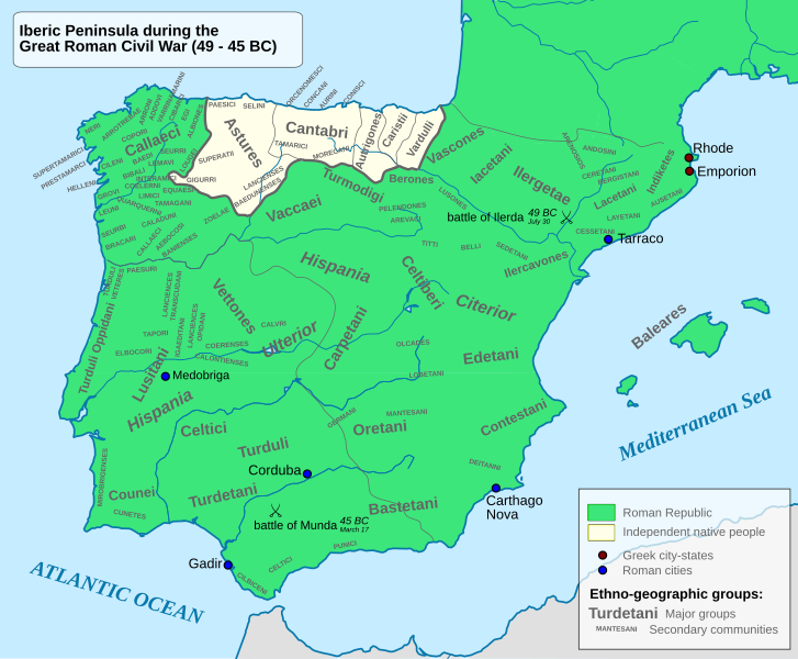
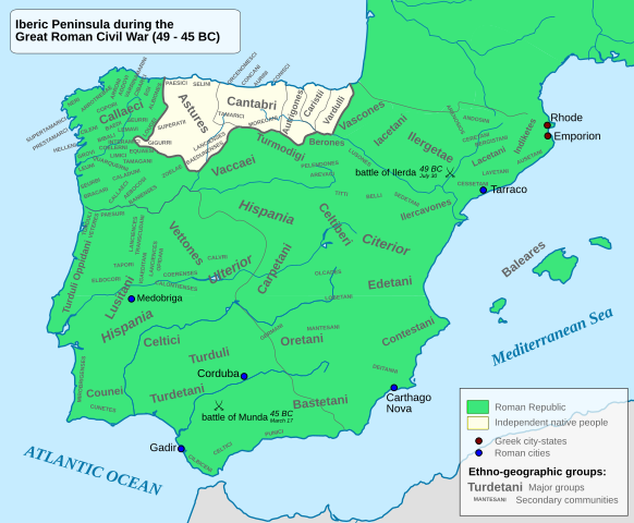
English: Iberian Peninsula during the Great Roman Civil War |
||
| Date | |||
| Source |
Native groups based on the map done by Portuguese Archeologist Luís Fraga, from the "Campo Arqueológico de Tavira"[1]. Borders based on the Eastern Hemisphere map of year 50 BCFile:East-Hem 050bc.jpg. Roman provinces based on the map found at this location [2]. |
||
| Author | Alcides Pinto | ||
| Permission (Reusing this file) |
I, the copyright holder of this work, hereby publish it under the following license:
|

![[2]](http://www.cprcalahorra.org/alfaro/Material/Historia%20de%20Espa%C3%B1a/Hispania%20Ulterior%20y%20Citerior.jpg)
File history
Click on a date/time to view the file as it appeared at that time.
| Date/Time | Thumbnail | Dimensions | User | Comment | |
|---|---|---|---|---|---|
| current | 11:11, 3 June 2010 | | 924 × 762 (308 KB) | Alcides Pinto (talk | contribs) | {{Information |Description={{en|1=Iberian Peninsula during the Great Roman Civil War}} |Source=Native groups based on the map done by Portuguese Archeologist Luís Fraga, from the "Campo Arqueológico de Tavira"[http://www.arkeotavira.com/Mapas/Iberia/Pop |
You cannot overwrite this file.
File usage on Commons
The following page uses this file:
File usage on other wikis
The following other wikis use this file:
- Usage on en.wikipedia.org
- Usage on es.wikipedia.org
- Usage on it.wikipedia.org
- Usage on ja.wikibooks.org
- Usage on pt.wikipedia.org