File:Indian stream map.png
Jump to navigation
Jump to search
Size of this preview: 800 × 575 pixels. Other resolutions: 320 × 230 pixels | 640 × 460 pixels | 1,024 × 736 pixels | 1,280 × 920 pixels | 1,617 × 1,162 pixels.
Original file (1,617 × 1,162 pixels, file size: 147 KB, MIME type: image/png)
Captions
Captions
Add a one-line explanation of what this file represents
Summary[edit]
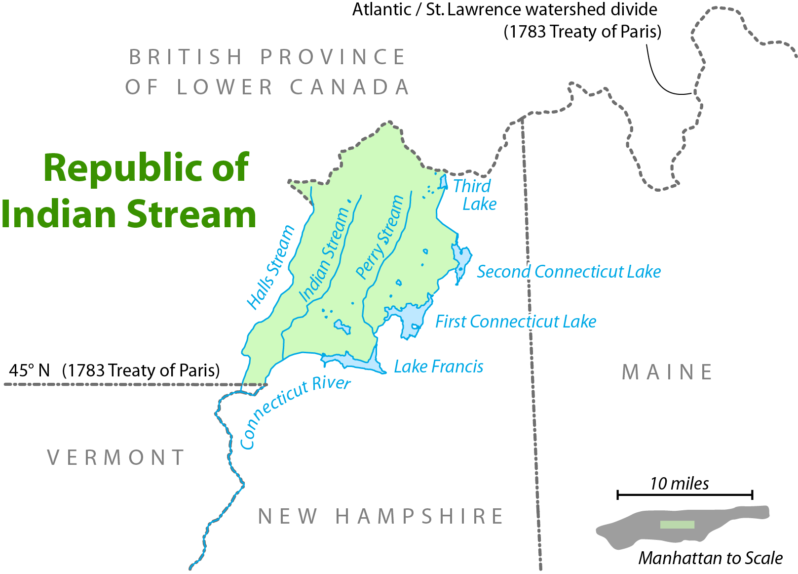
| Description | Map showing the location of the Republic of Indian Stream. I, Citynoise, am the creator of this map and hereby release it under the ShareAlike Attribution License. See www.radicalcartography.net for more. |
| Date | 18 June 2006 (original upload date) |
| Source | Transferred from en.wikipedia to Commons. |
| Author |
The original uploader was Citynoise at English Wikipedia. Later versions were uploaded by AnonMoos at en.wikipedia. |

|
This map image could be re-created using vector graphics as an SVG file. This has several advantages; see Commons:Media for cleanup for more information. If an SVG form of this image is available, please upload it and afterwards replace this template with
{{vector version available|new image name}}.
It is recommended to name the SVG file “Indian stream map.svg”—then the template Vector version available (or Vva) does not need the new image name parameter. |
Licensing[edit]
This file is licensed under the Creative Commons Attribution-Share Alike 2.5 Generic license.
- You are free:
- to share – to copy, distribute and transmit the work
- to remix – to adapt the work
- Under the following conditions:
- attribution – You must give appropriate credit, provide a link to the license, and indicate if changes were made. You may do so in any reasonable manner, but not in any way that suggests the licensor endorses you or your use.
- share alike – If you remix, transform, or build upon the material, you must distribute your contributions under the same or compatible license as the original.
Original upload log[edit]
The original description page was here. All following user names refer to en.wikipedia.
- 2006-09-28 11:01 AnonMoos 754×548×8 (92671 bytes) trimming excessive margins (whitespace), increasing PNG compression...
- 2006-06-27 00:48 Citynoise 800×600×8 (115636 bytes) fixed error in date of Treaty of Paris.
- 2006-06-18 03:09 Citynoise 800×600×8 (119474 bytes) Map showing the location of the Republic of Indian Stream. I, Citynoise, am the creator of this map and hereby release it under the ShareAlike Attribution License. See www.radicalcartography.net for more. Added scale.
- 2006-06-18 02:43 Citynoise 800×588×8 (118009 bytes) Map showing the location of the Republic of Indian Stream. I, Citynoise, am the creator of this map and hereby release it under the ShareAlike Attribution License. See www.radicalcartography.net for more.
File history
Click on a date/time to view the file as it appeared at that time.
| Date/Time | Thumbnail | Dimensions | User | Comment | |
|---|---|---|---|---|---|
| current | 17:56, 6 September 2016 | | 1,617 × 1,162 (147 KB) | Citynoise (talk | contribs) | Corrected name of Lower Canada |
| 17:03, 10 April 2007 |  | 754 × 548 (90 KB) | Liftarn (talk | contribs) | {{Information |Description=Map showing the location of the Republic of Indian Stream. I, Citynoise, am the creator of this map and hereby release it under the ShareAlike Attribution License. See www.radicalcartography.net for more. |Source=Originally fr |
You cannot overwrite this file.
File usage on Commons
The following page uses this file:
File usage on other wikis
The following other wikis use this file:
- Usage on ar.wikipedia.org
- Usage on bn.wikipedia.org
- Usage on de.wikipedia.org
- Usage on en.wikipedia.org
- Usage on en.wiktionary.org
- Usage on es.wikipedia.org
- Usage on et.wikipedia.org
- Usage on fr.wikipedia.org
- Usage on ja.wikipedia.org
- Usage on nl.wikipedia.org
- Usage on pt.wikipedia.org
- Usage on ru.wikipedia.org
- Usage on www.wikidata.org