File:Jeanne-22-1945z-T50-discussion2100z.png
Jump to navigation
Jump to search
No higher resolution available.
Jeanne-22-1945z-T50-discussion2100z.png (188 × 154 pixels, file size: 63 KB, MIME type: image/png)
Captions
Captions
Add a one-line explanation of what this file represents
Licensing[edit]
This image is in the public domain because it contains materials that originally came from the U.S. National Oceanic and Atmospheric Administration, taken or made as part of an employee's official duties.
|
Summary[edit]
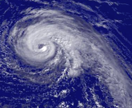
Hurricane Jeanne regional imagery, 2004.09.22 at 1945Z. Centerpoint Latitude: 26:13:30N Longitude: 70:06:12W.
Source: http://www.nnvl.noaa.gov/cgi-bin/index.cgi?page=items&ser=108310&large=1
Shortly after this image was taken the NHC quoted Dvorak T-Numbers of 5.0 from both the TAFB and SAB. [1]
References[edit]
File history
Click on a date/time to view the file as it appeared at that time.
| Date/Time | Thumbnail | Dimensions | User | Comment | |
|---|---|---|---|---|---|
| current | 13:12, 24 August 2006 | | 188 × 154 (63 KB) | Tropische Storm Sven~commonswiki (talk | contribs) | ==Licensing== {{PD-USGov-DOC-NOAA}} ==Summary== Hurricane Jeanne regional imagery, 2004.09.22 at 1945Z. Centerpoint Latitude: 26:13:30N Longitude: 70:06:12W. Source: http://www.nnvl.noaa.gov/cgi-bin/index.cgi?page=items&ser=108310&large=1 Shortly after |
You cannot overwrite this file.
File usage on Commons
There are no pages that use this file.
File usage on other wikis
The following other wikis use this file:
- Usage on ca.wikipedia.org
- Usage on de.wikipedia.org
- Usage on en.wikipedia.org
- Usage on es.wikipedia.org
- Usage on fr.wikipedia.org
- Usage on ja.wikipedia.org
- Usage on nl.wikipedia.org
- Usage on pt.wikipedia.org
- Usage on zh.wikipedia.org