File:Karte-Aartalbahn.png
Jump to navigation
Jump to search

Size of this preview: 430 × 599 pixels. Other resolutions: 172 × 240 pixels | 344 × 480 pixels | 551 × 768 pixels | 735 × 1,024 pixels | 1,400 × 1,950 pixels.
Original file (1,400 × 1,950 pixels, file size: 1.86 MB, MIME type: image/png)
Captions
Captions
Add a one-line explanation of what this file represents
| Description |
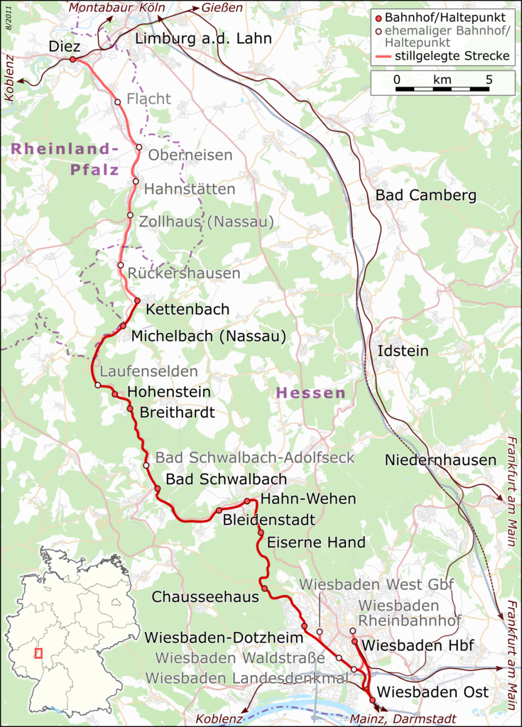
English: Railway Map Germany: Aartalbahn
Deutsch: Bahnkarte: Aartalbahn Wiesbaden -- Diez
This railway map was created from OpenStreetMap project data, collected by the community.This map may be incomplete, and may contain errors. Don't rely solely on it for navigation. |
| Date | see file history |
| Source |
Deutsch: Eigene Arbeit, nutzt
English: Own work, uses
|
| Author | Muns based on OpenStreetMap contributors |
| Permission (Reusing this file) |
All OpenStreetMap data and maps are Creative Commons "CC-BY-SA 2.0" licensed This file is licensed under the Creative Commons Attribution-Share Alike 2.0 Generic license.
|

|
This map has been made or improved in the German Kartenwerkstatt (Map Lab). You can propose maps to improve as well.
|
File history
Click on a date/time to view the file as it appeared at that time.
| Date/Time | Thumbnail | Dimensions | User | Comment | |
|---|---|---|---|---|---|
| current | 21:14, 8 August 2011 | | 1,400 × 1,950 (1.86 MB) | Muns (talk | contribs) | Breithardt wieder aktiv (das war doch schon mal richtig...) |
| 21:04, 8 August 2011 |  | 1,400 × 1,950 (1.86 MB) | Muns (talk | contribs) | Legende (Schrift) vergrößert | |
| 21:39, 2 August 2011 |  | 1,400 × 1,950 (1.86 MB) | Muns (talk | contribs) | Breithardt als aktiv markiert | |
| 21:24, 2 August 2011 |  | 1,400 × 1,950 (1.86 MB) | Muns (talk | contribs) | Schrift vergrößert, Streckenführung im Detail korr. | |
| 22:17, 5 July 2011 |  | 1,385 × 1,941 (1.8 MB) | Muns (talk | contribs) | Legende, stillgelegte Bahnhöfe/Haltepunkte grau beschriftet, Positionierung "Hessen", vgl. Anmerkungen Kartenwerkstatt | |
| 21:56, 4 July 2011 |  | 1,400 × 1,961 (1.82 MB) | Muns (talk | contribs) | {{Information |Description={{en|1=Railway Map Germany: Aartalbahn}} {{de|1=Bahnkarte: Aartalbahn Wiesbaden -- Diez}} This railway map was created from OpenStreetMap project data, collected by the community.<br/><small>This map may be incomplete, and |
You cannot overwrite this file.
File usage on Commons
The following 2 pages use this file:
File usage on other wikis
The following other wikis use this file:
- Usage on de.wikipedia.org
- Usage on en.wikipedia.org
- Usage on www.wikidata.org