File:Karte-Naturschutzkomplex-Zentralamazonien.jpg
Jump to navigation
Jump to search

Size of this preview: 800 × 423 pixels. Other resolutions: 320 × 169 pixels | 640 × 338 pixels | 1,060 × 560 pixels.
Original file (1,060 × 560 pixels, file size: 519 KB, MIME type: image/jpeg)
Captions
Captions
Add a one-line explanation of what this file represents
Summary[edit]
| Description |
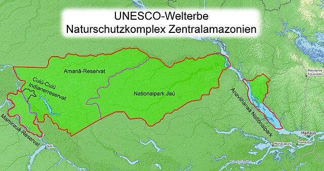
Deutsch: Karte des UNESCO-Welterbes "Naturschutzkomplex Zentralamazonien" |
| Date | |
| Source | Own work |
| Author | Fährtenleser |
Grundkarte: https://opentopomap.org/#map=8/-2.3669/-62.6990 (CC-BY-SA) Grenzen und Beschriftung: https://www.protectedplanet.net/central-amazon-conservation-complex-world-heritage-site-natural-or-mixed -und- http://whc.unesco.org/en/list/998
Licensing[edit]
I, the copyright holder of this work, hereby publish it under the following licenses:

|
Permission is granted to copy, distribute and/or modify this document under the terms of the GNU Free Documentation License, Version 1.2 or any later version published by the Free Software Foundation; with no Invariant Sections, no Front-Cover Texts, and no Back-Cover Texts. A copy of the license is included in the section entitled GNU Free Documentation License. |
This file is licensed under the Creative Commons Attribution 3.0 Unported license.
- You are free:
- to share – to copy, distribute and transmit the work
- to remix – to adapt the work
- Under the following conditions:
- attribution – You must give appropriate credit, provide a link to the license, and indicate if changes were made. You may do so in any reasonable manner, but not in any way that suggests the licensor endorses you or your use.
You may select the license of your choice.
File history
Click on a date/time to view the file as it appeared at that time.
| Date/Time | Thumbnail | Dimensions | User | Comment | |
|---|---|---|---|---|---|
| current | 05:43, 9 April 2020 | | 1,060 × 560 (519 KB) | Fährtenleser (talk | contribs) | Tippfehler im Titel |
| 04:51, 4 April 2020 |  | 1,060 × 560 (533 KB) | Fährtenleser (talk | contribs) | {{Information |description ={{de|1=Karte des UNESCO-Welterbes "Naturschutzkomplex Zentralamazonien"}} |date =2020-04-04 |source ={{own}} |author =User:Fährtenleser }} Grundkarte: https://opentopomap.org/#map=8/-2.3669/-62.6990 (CC-BY-SA) Grenzen und Beschriftung: https://www.protectedplanet.net/central-amazon-conservation-complex-world-heritage-site-natural-or-mixed -und- http://whc.unesco.org/en/list/998 Category:Maps of Brazil Category:Maps of Amazon Basin |
You cannot overwrite this file.
File usage on Commons
There are no pages that use this file.
File usage on other wikis
The following other wikis use this file:
- Usage on de.wikipedia.org