File:Karte Grand Dixence.svg
Jump to navigation
Jump to search

Size of this PNG preview of this SVG file: 800 × 487 pixels. Other resolutions: 320 × 195 pixels | 640 × 390 pixels | 1,024 × 623 pixels | 1,280 × 779 pixels | 2,560 × 1,558 pixels | 1,076 × 655 pixels.
Original file (SVG file, nominally 1,076 × 655 pixels, file size: 1.44 MB)
Captions
Captions
Add a one-line explanation of what this file represents
Summary[edit]
| Description |
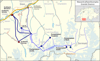
Deutsch: Lagekarte der Anlagen des Wasserkraftwerkkomplexes Grande Dixence. SVG-Version |
|||||||||
| Date | ||||||||||
| Source |
Map was created using:
|
|||||||||
| Creator | ||||||||||
| Permission (Reusing this file) |
Map data (c) OpenStreetMap (and) contributors, CC-BY-SA | |||||||||
| Geotemporal data | ||||||||||
| Bounding box |
|
|||||||||
| Other versions |
png-Version:  |
|||||||||
Licensing[edit]
I, the copyright holder of this work, hereby publish it under the following license:
This file is licensed under the Creative Commons Attribution 3.0 Unported license.
- You are free:
- to share – to copy, distribute and transmit the work
- to remix – to adapt the work
- Under the following conditions:
- attribution – You must give appropriate credit, provide a link to the license, and indicate if changes were made. You may do so in any reasonable manner, but not in any way that suggests the licensor endorses you or your use.
| This work is licensed under the Open Database License (summary). |
File history
Click on a date/time to view the file as it appeared at that time.
| Date/Time | Thumbnail | Dimensions | User | Comment | |
|---|---|---|---|---|---|
| current | 21:03, 5 August 2023 | | 1,076 × 655 (1.44 MB) | Pechristener (talk | contribs) | Reverted to version as of 08:40, 6 May 2020 (UTC) because the power plants Nendaz and Fionnay are back in operation since January 2023. |
| 05:10, 7 May 2020 |  | 1,076 × 655 (1.55 MB) | Pechristener (talk | contribs) | New version showing also the powerhouses Nendaz and Fionnay as mothballed. These powerhouses shall be put back in operation in 2023. | |
| 08:40, 6 May 2020 |  | 1,076 × 655 (1.44 MB) | Pechristener (talk | contribs) | {{Map |Description={{de|1=Lagekarte der Anlagen des Wasserkraftwerkkomplexes Grande Dixence. SVG-Version}} |Source=Map was created using: *[http://www.openstreetmap.org/ Open Street Map] *Switzerland location map.svg for location map |Author = *Pechristener *File:Switzerland location map.svg: NordNordWest |Date =2020-05-06 |Permission =Map data (c)... |
You cannot overwrite this file.
File usage on Commons
The following page uses this file:
File usage on other wikis
The following other wikis use this file:
- Usage on de.wikipedia.org
- Usage on uk.wikipedia.org