File:KesemNorth.jpg
Jump to navigation
Jump to search

Size of this preview: 800 × 600 pixels. Other resolutions: 320 × 240 pixels | 640 × 480 pixels | 1,024 × 767 pixels | 1,280 × 959 pixels | 2,560 × 1,919 pixels | 4,056 × 3,040 pixels.
Original file (4,056 × 3,040 pixels, file size: 6.25 MB, MIME type: image/jpeg)
Captions
Captions
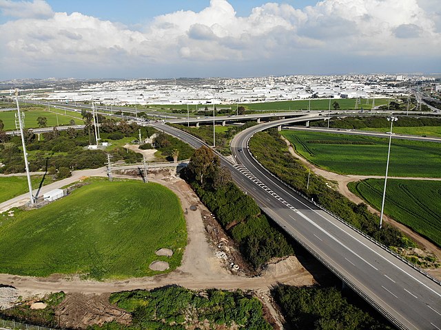
The northern part of Kesem Interchange
Summary[edit]
| Description |
עברית: מבט לכיוון מזרח על החלק הצפוני של מחלף קסם.
בחלקה הימני-התחתון של התמונה - רמפה לכביש 5 לכיוון מערב. הדרכים שמתחברות אליה הן כביש 444 וגשר מכיוון כביש 6. ברקע בצד שמאל - כביש 6 ברקע בצד ימין - כביש 5 לכיוון מזרח ברקע במרכז התמונה - אזור התעשייה של כפר-קאסם |
| Date | |
| Source | Own work |
| Author | גיא אביב |
| Camera location | | View this and other nearby images on: OpenStreetMap |
|---|
Licensing[edit]
I, the copyright holder of this work, hereby publish it under the following license:
This file is licensed under the Creative Commons Attribution-Share Alike 4.0 International license.
- You are free:
- to share – to copy, distribute and transmit the work
- to remix – to adapt the work
- Under the following conditions:
- attribution – You must give appropriate credit, provide a link to the license, and indicate if changes were made. You may do so in any reasonable manner, but not in any way that suggests the licensor endorses you or your use.
- share alike – If you remix, transform, or build upon the material, you must distribute your contributions under the same or compatible license as the original.
File history
Click on a date/time to view the file as it appeared at that time.
| Date/Time | Thumbnail | Dimensions | User | Comment | |
|---|---|---|---|---|---|
| current | 19:25, 23 February 2019 | | 4,056 × 3,040 (6.25 MB) | גיא אביב (talk | contribs) | User created page with UploadWizard |
You cannot overwrite this file.
File usage on Commons
There are no pages that use this file.