File:Kuwaiti islands.jpg
Jump to navigation
Jump to search

Size of this preview: 667 × 600 pixels. Other resolutions: 267 × 240 pixels | 534 × 480 pixels | 854 × 768 pixels | 1,139 × 1,024 pixels | 2,277 × 2,048 pixels | 4,242 × 3,815 pixels.
Original file (4,242 × 3,815 pixels, file size: 5.39 MB, MIME type: image/jpeg)
Captions
Captions
Add a one-line explanation of what this file represents
Summary[edit]
| Kuwaiti islands | |
|---|---|
| Photographer |
Envisat satellite |
| Title |
Kuwaiti islands |
| Description |
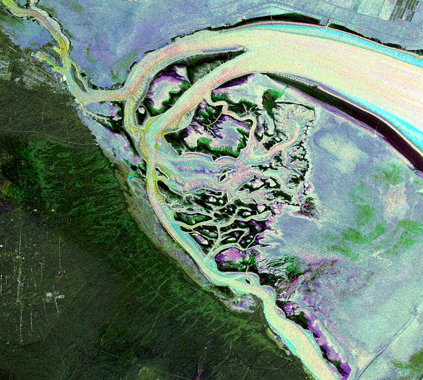
English: This Envisat image features the Kuwait islands of Warbah and Bubiyan, located at the head of the Persian Gulf.
What appears to be water across the top and right side of the image (lilac, green and blue) is land. The brighter yellow, aqua and pink colours represent water. Here, the water currents in these channels can be observed thanks to the radar imagery as they flow out into the gulf. The image was created by combining three Advanced Synthetic Aperture Radar (ASAR) acquisitions (22 August 2009, 26 September 2009 and 31 October 2009) taken over the same area. The colours in the image result from variations in the surface that occurred between acquisitions. |
| Depicted place | Kuwait |
| Date | between 22 August 2009 and 31 October 2009 |
| Collection | European Space Agency |
| Accession number |
236846 |
| Credit line | ESA |
| Source | http://www.esa.int/spaceinimages/Images/2010/02/Kuwaiti_islands |
Licensing[edit]
This file is licensed under the Creative Commons Attribution-ShareAlike 3.0 IGO license.
- You are free:
- to share – to copy, distribute and transmit the work
- to remix – to adapt the work
- Under the following conditions:
- attribution – You must give appropriate credit, provide a link to the license, and indicate if changes were made. You may do so in any reasonable manner, but not in any way that suggests the licensor endorses you or your use.
- share alike – If you remix, transform, or build upon the material, you must distribute your contributions under the same or compatible license as the original.
File history
Click on a date/time to view the file as it appeared at that time.
| Date/Time | Thumbnail | Dimensions | User | Comment | |
|---|---|---|---|---|---|
| current | 07:12, 27 February 2017 | | 4,242 × 3,815 (5.39 MB) | Revent (talk | contribs) | =={{int:filedesc}}== {{Photograph |photographer = Envisat satellite |title = Kuwaiti islands |description = {{en|1=This Envisat image features the Kuwait islands of Warbah and Bubiyan, located at the head of the Persian Gul... |
You cannot overwrite this file.
File usage on Commons
The following 4 pages use this file:
File usage on other wikis
The following other wikis use this file:
- Usage on cs.wikipedia.org
- Usage on de.wikipedia.org
- Usage on en.wikipedia.org
- Usage on es.wikipedia.org
- Usage on fr.wikipedia.org
- Usage on pt.wikipedia.org
- Usage on uk.wikipedia.org