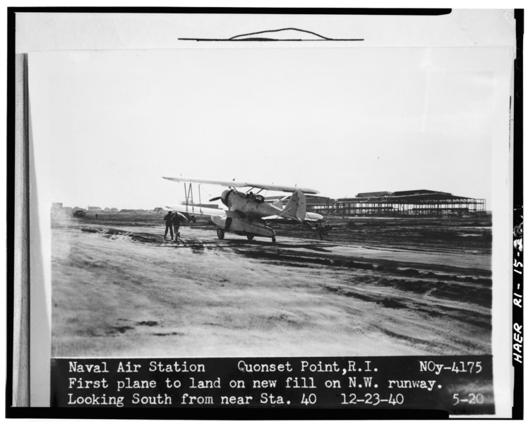
File:LOOKING SOUTH AT FIRST PLANE TO LAND ON FILL (RUNWAY 16-34) LANDPLANE HANGARS (BLDGS. 3-4) VISIBLE IN BACKGROUND. USN PHOTO, DECEMBER 23, 1940. - Quonset Point Naval Air Station, HAER RI,5-KINGN,6-22.tif
Jump to navigation
Jump to search
Size of this JPG preview of this TIF file: 748 × 600 pixels. Other resolutions: 299 × 240 pixels | 599 × 480 pixels | 958 × 768 pixels | 1,277 × 1,024 pixels | 2,554 × 2,048 pixels | 4,890 × 3,922 pixels.
Original file (4,890 × 3,922 pixels, file size: 18.29 MB, MIME type: image/tiff)
Captions
Captions
Add a one-line explanation of what this file represents
Summary[edit]
| LOOKING SOUTH AT FIRST PLANE TO LAND ON FILL (RUNWAY 16-34) LANDPLANE HANGARS (BLDGS. 3-4) VISIBLE IN BACKGROUND. USN PHOTO, DECEMBER 23, 1940. - Quonset Point Naval Air Station, Roger Williams Way, North Kingstown, Washington County, RI | ||||
|---|---|---|---|---|
| Title |
LOOKING SOUTH AT FIRST PLANE TO LAND ON FILL (RUNWAY 16-34) LANDPLANE HANGARS (BLDGS. 3-4) VISIBLE IN BACKGROUND. USN PHOTO, DECEMBER 23, 1940. - Quonset Point Naval Air Station, Roger Williams Way, North Kingstown, Washington County, RI |
|||
| Description |
Albert Kahn,Incorporated; George A Fuller Company; Merritt-Chapman and Scott Corporation |
|||
| Depicted place | Rhode Island; Washington County; North Kingstown | |||
| Date | Documentation compiled after 1968 | |||
| Dimensions | 4 x 5 in. | |||
| Current location |
Library of Congress Prints and Photographs Division Washington, D.C. 20540 USA http://hdl.loc.gov/loc.pnp/pp.print |
|||
| Accession number |
HAER RI,5-KINGN,6-22 |
|||
| Credit line |
|
|||
| Notes |
|
|||
| Source | https://www.loc.gov/pictures/item/ri0347.photos.146392p | |||
| Permission (Reusing this file) |
|
|||

File history
Click on a date/time to view the file as it appeared at that time.
| Date/Time | Thumbnail | Dimensions | User | Comment | |
|---|---|---|---|---|---|
| current | 21:43, 1 August 2014 |  | 4,890 × 3,922 (18.29 MB) | Fæ (talk | contribs) | GWToolset: Creating mediafile for Fæ. HABS 31 July 2014 (3000:3200) |
You cannot overwrite this file.
File usage on Commons
The following page uses this file: