File:Lake tana.jpg
Jump to navigation
Jump to search
Size of this preview: 614 × 600 pixels. Other resolutions: 246 × 240 pixels | 639 × 624 pixels.
Original file (639 × 624 pixels, file size: 166 KB, MIME type: image/jpeg)
Captions
Captions
Add a one-line explanation of what this file represents
Summary[edit]
| Description |
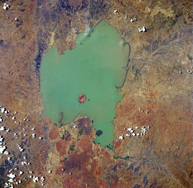
English: Lake Tana, Ethiopia - April 1991. Low-oblique, west-looking photograph (now after 270 degree rotation north-looking). Located in the central highlands of Ethiopia, Lake Tana, the country’s largest lake, covers 1400 square miles (3625 square kilometers). The lake is 47 miles (76 kilometers) long and 44 miles (71 kilometers) wide and sits at an elevation of 6000 feet (1830 meters) above sea level.
Ελληνικά: Δορυφορική φωτογραφία της Λίμνης Τάνα στην Αιθιοπία |
| Date | |
| Source | Image Science and Analysis Laboratory, NASA-Johnson Space Center, The Gateway to Astronaut Photography of Earth: STS037-84-3 |
| Author | NASA |
Licensing[edit]
| This file is in the public domain in the United States because it was solely created by NASA. NASA copyright policy states that "NASA material is not protected by copyright unless noted". (See Template:PD-USGov, NASA copyright policy page or JPL Image Use Policy.) | ||
 |
Warnings:
|
File history
Click on a date/time to view the file as it appeared at that time.
| Date/Time | Thumbnail | Dimensions | User | Comment | |
|---|---|---|---|---|---|
| current | 07:45, 3 December 2012 | | 639 × 624 (166 KB) | Rotatebot (talk | contribs) | Bot: Image rotated by 270° |
| 01:49, 13 August 2005 |  | 639 × 639 (150 KB) | Boticario (talk | contribs) | Lake Tana, Ethiopia - April 1991 image description [http://eol.jsc.nasa.gov/sseop/EFS/photoinfo.pl?PHOTO=STS037-84-3 here] {{PD-USGov-NASA}} |
You cannot overwrite this file.
File usage on Commons
The following 3 pages use this file:
File usage on other wikis
The following other wikis use this file:
- Usage on af.wikipedia.org
- Usage on ar.wikipedia.org
- Usage on azb.wikipedia.org
- Usage on az.wikipedia.org
- Usage on bn.wikipedia.org
- Usage on br.wikipedia.org
- Usage on ca.wikipedia.org
- Usage on ceb.wikipedia.org
- Usage on cs.wikipedia.org
- Usage on da.wikipedia.org
- Usage on de.wikipedia.org
- Usage on el.wikipedia.org
- Usage on en.wikipedia.org
- Usage on eo.wikipedia.org
- Usage on es.wikipedia.org
- Usage on fa.wikipedia.org
- Usage on fi.wikipedia.org
- Usage on fr.wikipedia.org
- Usage on gl.wikipedia.org
- Usage on he.wikipedia.org
- Usage on hr.wikipedia.org
- Usage on hu.wikipedia.org
- Usage on id.wikipedia.org
- Usage on is.wikipedia.org
- Usage on it.wikipedia.org
- Usage on ja.wikipedia.org
- Usage on ka.wikipedia.org
- Usage on kn.wikipedia.org
- Usage on ko.wikipedia.org
- Usage on ky.wikipedia.org
- Usage on la.wikipedia.org
- Usage on lv.wikipedia.org
- Usage on mk.wikipedia.org
- Usage on ml.wikipedia.org
- Usage on my.wikipedia.org
- Usage on nl.wikipedia.org
- Usage on no.wikipedia.org
- Usage on oc.wikipedia.org
- Usage on pnb.wikipedia.org
- Usage on pt.wikipedia.org
- Usage on ro.wikipedia.org
- Usage on sh.wikipedia.org
- Usage on sl.wikipedia.org
- Usage on sr.wikipedia.org
View more global usage of this file.