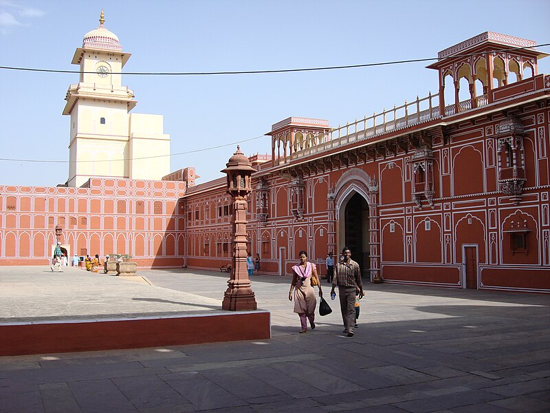
File:Lascar City Palace (Jaipur) (4499866752).jpg
From Wikimedia Commons, the free media repository
Jump to navigation
Jump to search

Size of this preview: 800 × 600 pixels. Other resolutions: 320 × 240 pixels | 640 × 480 pixels | 1,024 × 768 pixels | 1,280 × 960 pixels | 2,592 × 1,944 pixels.
Original file (2,592 × 1,944 pixels, file size: 2.12 MB, MIME type: image/jpeg)
File information
Structured data
Captions
Captions
Add a one-line explanation of what this file represents
Summary[edit]
| DescriptionLascar City Palace (Jaipur) (4499866752).jpg | Located in the capital of Rajasthan, the City Palace of Jaipur or the main palace is an imposing blend of traditional Rajasthan and Mughal architecture. The vast palace complex occupies one seventh of the walled city of Jaipur. Originally built by Maharaja Jai Singh II of the Kachhwaha clan of Rajputs, additions have been made to the palace complex by many of his successors. The complex is divided into a series of courtyards, sprawling gardens and buildings. It is home to several palatial structures like the Chandra Mahal, Mubarak Mahal, Badal Mahal, Shri Govind Dev Temple and the City Palace Museum. In the first courtyard is the 'Mubarak Mahal', built by Maharaja Madho Singh II in the late 19th century. The Mubarak Mahal, or the Auspicious Palace, contains the textile section of the Maharaja Sawai Man Singh II Museum. There is a magnificent gateway with a grand door in brass opening to a stately courtyard. There lies the Diwan-I-Khas or 'Hall of Private Audience'- an open hall with a double row of columns with scalloped arches. On display are the two largest silver vessels in the world figured in the Guinness Book of World Records. These were used for carrying water from the holy Ganges for personal use, by Madho Singh II on his journey to England. Across the paved square, with its intricate decorations in deep red and gold, Afghan and Persian carpets, miniature paintings, astronomical manuscripts in Persian and Sanskrit lies the 'Diwan-E-Aam' or the 'Hall of Public Audience'. At the other corner is the gateway Ridhi Sidhi Pol, with four small doorways decorated with motifs depicting the four seasons. [Webindia123.com] |
| Date | |
| Source | City Palace (Jaipur) |
| Author | Jorge Láscar from Australia |
| Camera location | 26° 55′ 31.8″ N, 75° 49′ 24.96″ E | View this and other nearby images on: OpenStreetMap |
|---|
Licensing[edit]
This file is licensed under the Creative Commons Attribution 2.0 Generic license.
- You are free:
- to share – to copy, distribute and transmit the work
- to remix – to adapt the work
- Under the following conditions:
- attribution – You must give appropriate credit, provide a link to the license, and indicate if changes were made. You may do so in any reasonable manner, but not in any way that suggests the licensor endorses you or your use.
| This image was originally posted to Flickr by Jorge Lascar at https://www.flickr.com/photos/8721758@N06/4499866752. It was reviewed on 2 April 2014 by FlickreviewR and was confirmed to be licensed under the terms of the cc-by-2.0. |
2 April 2014
File history
Click on a date/time to view the file as it appeared at that time.
| Date/Time | Thumbnail | Dimensions | User | Comment | |
|---|---|---|---|---|---|
| current | 09:23, 2 April 2014 |  | 2,592 × 1,944 (2.12 MB) | Russavia (talk | contribs) | Transferred from Flickr |
You cannot overwrite this file.
File usage on Commons
There are no pages that use this file.
Metadata
This file contains additional information such as Exif metadata which may have been added by the digital camera, scanner, or software program used to create or digitize it. If the file has been modified from its original state, some details such as the timestamp may not fully reflect those of the original file. The timestamp is only as accurate as the clock in the camera, and it may be completely wrong.
| Camera manufacturer | SONY |
|---|---|
| Camera model | DSC-N2 |
| Exposure time | 1/250 sec (0.004) |
| F-number | f/8 |
| ISO speed rating | 160 |
| Date and time of data generation | 15:56, 23 April 2007 |
| Lens focal length | 7.9 mm |
| Orientation | Normal |
| Horizontal resolution | 72 dpi |
| Vertical resolution | 72 dpi |
| File change date and time | 15:56, 23 April 2007 |
| Y and C positioning | Co-sited |
| Exposure Program | Normal program |
| Exif version | 2.21 |
| Date and time of digitizing | 15:56, 23 April 2007 |
| Meaning of each component |
|
| Image compression mode | 8 |
| APEX exposure bias | 0 |
| Maximum land aperture | 3 APEX (f/2.83) |
| Metering mode | Pattern |
| Light source | Unknown |
| Flash | Flash did not fire, compulsory flash suppression |
| Supported Flashpix version | 1 |
| Color space | sRGB |
| File source | Digital still camera |
| Scene type | A directly photographed image |
| Custom image processing | Normal process |
| Exposure mode | Auto exposure |
| White balance | Auto white balance |
| Scene capture type | Standard |
| Contrast | Normal |
| Saturation | Normal |
| Sharpness | Normal |