File:Le Casino Zane (Venise) (9987813334).jpg

Original file (1,344 × 1,011 pixels, file size: 1,014 KB, MIME type: image/jpeg)
Captions
Captions
Summary[edit]
_(9987813334).jpg&action=edit§ion=1)
| Description |
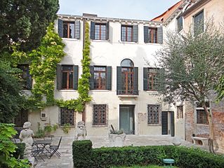
Le jardin et l'entrée du palazzetto Bru Zane Situé dans le quartier de San Stin, le casino Zane, édifié entre 1695 et 1697, fut pendant un siècle le palais de divertissement du palazzo Zane, construit à quelques dizaines de mètres. En 1682, l’atelier de Baldassare Longhena – célèbre architecte du baroque vénitien, achève la restructuration du palazzo Zane commandée par Dominico Zane. A la mort de ce dernier, son neveu et héritier Marino Zane. initie la construction du casino et de la bibliothèque pour préserver les collections de son oncle, qu’il s’était employé à enrichir. L’architecte Antonio Gaspari, issu de l’atelier de Longhena, eut pleine liberté pour concevoir le casino. À sa mort, son assistant Domenico Rossi poursuivit ses projets, épaulé par des artistes de renom. La décoration intérieure, très riche, est ainsi attribuée au célèbre stucateur Abbondio Stazio et la balustrade en bois qui surplombe la salle de bal proviendrait de l’atelier du sculpteur Andrea Brustolon. Les fresques sont – depuis peu – attribuées à Sebastiano Ricci. En 2006 une étude historique a été réalisée, en lien avec la Surintendance des beaux-arts de Venise et, en 2007, un vaste chantier de restauration a été engagé par la Fondation Bru. Le projet est double : réhabiliter le bâtiment dans l’esprit de l’époque et y créer un lieu dédié à la musique, qui était sa finalité première. La fondation Palazzetto Bru Zane – Centre de musique romantique française a été créée en janvier 2008 pour redonner vie à ce lieu grâce à la musique. Extraits du site officielwww.bru-zane.com/?lang=fr |
| Date | |
| Source | Le Casino Zane (Venise) |
| Author | Jean-Pierre Dalbéra from Paris, France |
| Camera location | | View this and other nearby images on: OpenStreetMap |
|---|
_(9987813334).jpg¶ms=045.438807_N_0012.326606_E_globe:Earth_type:camera_source:Flickr_&language=en)
Licensing[edit]
_(9987813334).jpg&action=edit§ion=2)
- You are free:
- to share – to copy, distribute and transmit the work
- to remix – to adapt the work
- Under the following conditions:
- attribution – You must give appropriate credit, provide a link to the license, and indicate if changes were made. You may do so in any reasonable manner, but not in any way that suggests the licensor endorses you or your use.
| This image was originally posted to Flickr by dalbera at https://www.flickr.com/photos/72746018@N00/9987813334. It was reviewed on 9 December 2014 by FlickreviewR and was confirmed to be licensed under the terms of the cc-by-2.0. |
File history
Click on a date/time to view the file as it appeared at that time.
| Date/Time | Thumbnail | Dimensions | User | Comment | |
|---|---|---|---|---|---|
| current | 15:39, 15 December 2014 | | 1,344 × 1,011 (1,014 KB) | Lomita (talk | contribs) | suppression cadre |
| 15:53, 9 December 2014 |  | 1,365 × 1,024 (1.37 MB) | Medium69 (talk | contribs) | Transferred from Flickr via Flickr2Commons |
You cannot overwrite this file.
File usage on Commons
The following 2 pages use this file:
File usage on other wikis
The following other wikis use this file:
- Usage on de.wikipedia.org
- Usage on en.wikipedia.org
- Usage on fr.wikipedia.org
- Usage on it.wikipedia.org
- Usage on it.wikivoyage.org
- Usage on www.wikidata.org
_(9987813334).jpg&oldid=752742610)