File:Ligne H, schéma de ligne.png
Jump to navigation
Jump to search
Size of this preview: 800 × 445 pixels. Other resolutions: 320 × 178 pixels | 640 × 356 pixels | 1,024 × 570 pixels | 1,280 × 712 pixels | 2,560 × 1,424 pixels.
Original file (2,560 × 1,424 pixels, file size: 522 KB, MIME type: image/png)
Captions
Captions
Add a one-line explanation of what this file represents
Summary[edit]
| Description |
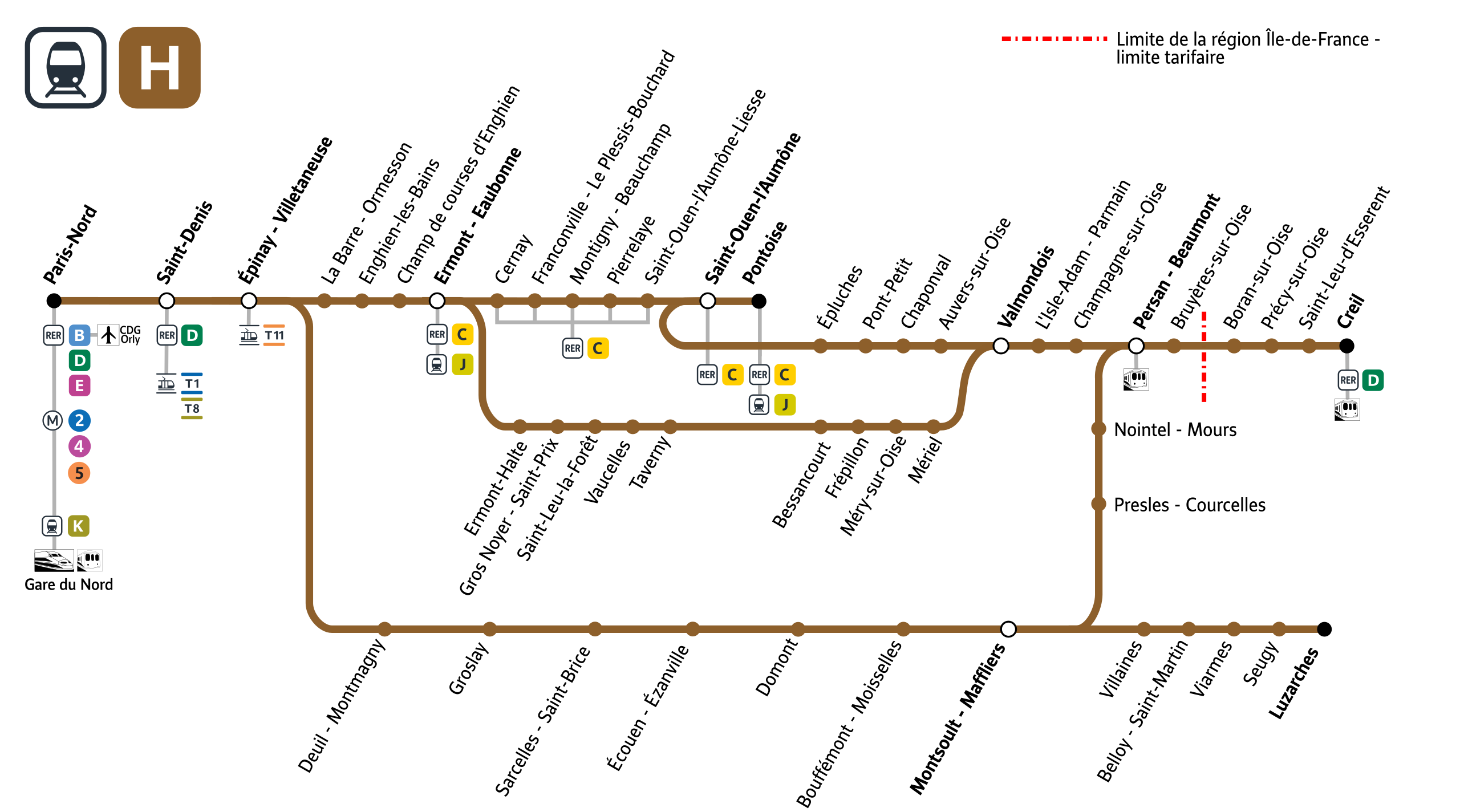
Français : Plan schématique de la ligne H du Transilien avec indication des correspondances (RER, Transilien, métro et tram). |
|||
| Date | ||||
| Source | Own work | |||
| Author | P.poschadel | |||
| Other versions |
|


Licensing[edit]
I, the copyright holder of this work, hereby publish it under the following licenses:

|
Permission is granted to copy, distribute and/or modify this document under the terms of the GNU Free Documentation License, Version 1.2 or any later version published by the Free Software Foundation; with no Invariant Sections, no Front-Cover Texts, and no Back-Cover Texts. A copy of the license is included in the section entitled GNU Free Documentation License. |
This file is licensed under the Creative Commons Attribution-Share Alike 3.0 Unported, 2.5 Generic, 2.0 Generic and 1.0 Generic license.
- You are free:
- to share – to copy, distribute and transmit the work
- to remix – to adapt the work
- Under the following conditions:
- attribution – You must give appropriate credit, provide a link to the license, and indicate if changes were made. You may do so in any reasonable manner, but not in any way that suggests the licensor endorses you or your use.
- share alike – If you remix, transform, or build upon the material, you must distribute your contributions under the same or compatible license as the original.
You may select the license of your choice.
File history
Click on a date/time to view the file as it appeared at that time.
| Date/Time | Thumbnail | Dimensions | User | Comment | |
|---|---|---|---|---|---|
| current | 07:58, 14 June 2021 | | 2,560 × 1,424 (522 KB) | Trainsandstations (talk | contribs) | Nouveaux pictos IDFM (déjà utilisés sur Wiki). Changement de couleur de la ligne. Ajout du T8 à Saint-Denis, du T11 à Epinay-V., du RER C à Cernay, Franconville, Pierrelaye, Saint-Ouen l'A Liesse et Pontoise (pour le T8, T11, RER C cela était déjà fait sur la version non vectorielle). Remplacement de l'Arial par la police IDFVoyageur disponible en OpenData CC BY-NC-ND 3.0 FR. |
| 08:29, 20 September 2019 |  | 2,000 × 1,161 (668 KB) | Kvardek du (talk | contribs) | màj d'après https://commons.wikimedia.org/wiki/File:Ligne_H,_sch%C3%A9ma_de_ligne.svg (correspondance T11 notamment) | |
| 00:12, 8 September 2016 |  | 2,067 × 1,200 (445 KB) | M0tty (talk | contribs) | Merci de ne pas diminuer les dimensions du fichier. Reverted to version as of 07:53, 14 December 2012 (UTC) | |
| 15:57, 7 September 2016 |  | 600 × 323 (90 KB) | The BurnPheonix (talk | contribs) | + CORRESPONDANCES | |
| 15:05, 7 September 2016 |  | 600 × 323 (89 KB) | The BurnPheonix (talk | contribs) | T8 ST DENIS | |
| 15:04, 7 September 2016 |  | 600 × 323 (89 KB) | The BurnPheonix (talk | contribs) | + CORR | |
| 15:03, 7 September 2016 |  | 600 × 323 (89 KB) | The BurnPheonix (talk | contribs) | NOUVELLES CORRESPONDANCES | |
| 07:53, 14 December 2012 |  | 2,067 × 1,200 (445 KB) | P.poschadel (talk | contribs) | + limite tarifaire. | |
| 18:31, 7 December 2012 |  | 930 × 540 (141 KB) | P.poschadel (talk | contribs) | Div. corrections. | |
| 18:40, 6 December 2012 |  | 930 × 540 (141 KB) | P.poschadel (talk | contribs) | Modif. Paris-Nord. |
You cannot overwrite this file.
File usage on Commons
The following 8 pages use this file:
- User:Chumwa/OgreBot/Potential transport maps/2019 September 11-20
- User:Chumwa/OgreBot/Public transport information/2019 September 11-20
- User:Chumwa/OgreBot/Public transport information/2021 June 11-20
- User:Chumwa/OgreBot/Transport Maps/2019 September 11-20
- User:Chumwa/OgreBot/Transport Maps/2021 June 11-20
- User:Chumwa/OgreBot/Travel and communication maps/2019 September 11-20
- User:Minorax/SVG available/2021 June 13-18
- File:Ligne H, schéma de ligne.svg