File:LitockiWall 01.jpg
Original file (2,443 × 1,710 pixels, file size: 1.38 MB, MIME type: image/jpeg)
Captions
Summary[edit]
DescriptionLitockiWall 01.jpg |
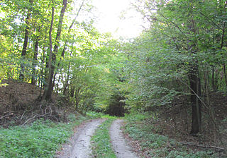
Українська: Залишки валів древнього городища поблизу с. Літочки Броварського району. Скоріш за все це так звані "Срібні Ворота"
|
||
Date | |||
Source | Own work | ||
Author | Scunk |
Camera location | 50° 45′ 32.67″ N, 30° 48′ 31.02″ E | View this and other nearby images on: OpenStreetMap | 50.759075; 30.808617 |
---|
Пам'ятка знаходиться на території державного заказника "Залісся", а простіше - мисливських угіддях президента, тому простим смертним туди вхід заборонений. По цій причині довелось лізти через паркан, і не бралась хороша фототехніка. Як потім виявилось, під час фотографування попав бруд на об'єктив і всі фотографії запоролись. Тому вдалось вирізати лише ці шматки. Хоча на них все дуже погано видно, але іншого не маємо :( Можливо, журналісти зможуть отримати офіційно доступ туди і зробити якісні фотогрфії.
Licensing[edit]
- You are free:
- to share – to copy, distribute and transmit the work
- to remix – to adapt the work
- Under the following conditions:
- attribution – You must give appropriate credit, provide a link to the license, and indicate if changes were made. You may do so in any reasonable manner, but not in any way that suggests the licensor endorses you or your use.
- share alike – If you remix, transform, or build upon the material, you must distribute your contributions under the same or compatible license as the original.
This image was uploaded as part of Wiki Loves Monuments 2012.
Afrikaans ∙ Alemannisch ∙ azərbaycanca ∙ Bahasa Indonesia ∙ Bahasa Melayu ∙ Bikol Central ∙ bosanski ∙ brezhoneg ∙ català ∙ čeština ∙ Cymraeg ∙ dansk ∙ davvisámegiella ∙ Deutsch ∙ eesti ∙ English ∙ español ∙ Esperanto ∙ euskara ∙ français ∙ Frysk ∙ Gaeilge ∙ galego ∙ hrvatski ∙ Ido ∙ italiano ∙ latviešu ∙ Lëtzebuergesch ∙ Malagasy ∙ magyar ∙ Malti ∙ Nederlands ∙ norsk ∙ norsk nynorsk ∙ norsk bokmål ∙ polski ∙ português ∙ português do Brasil ∙ română ∙ shqip ∙ sicilianu ∙ slovenčina ∙ slovenščina ∙ suomi ∙ svenska ∙ Tagalog ∙ Türkçe ∙ Yorùbá ∙ Zazaki ∙ Ελληνικά ∙ беларуская ∙ беларуская (тарашкевіца) ∙ български ∙ кыргызча ∙ македонски ∙ русский ∙ српски / srpski ∙ українська ∙ ქართული ∙ հայերեն ∙ नेपाली ∙ हिन्दी ∙ বাংলা ∙ മലയാളം ∙ ไทย ∙ 한국어 ∙ +/− |
File history
Click on a date/time to view the file as it appeared at that time.
Date/Time | Thumbnail | Dimensions | User | Comment | |
---|---|---|---|---|---|
current | 15:47, 30 September 2012 | 2,443 × 1,710 (1.38 MB) | Scunk~commonswiki (talk | contribs) | User created page with UploadWizard |
You cannot overwrite this file.
File usage on Commons
The following 3 pages use this file:
File usage on other wikis
The following other wikis use this file:
- Usage on nl.wikipedia.org
- Usage on ru.wikipedia.org
- Usage on uk.wikipedia.org
- Національний природний парк «Залісся»
- Користувач:ErfgoedBot/Images of Cultural heritage monuments without ID
- Вікіпедія:Вікі любить пам'ятки/старий АТУ/Київська область/Броварський район
- Природно-заповідний фонд Київської області
- Вікіпедія:Wiki Loves Earth/Київська область/Броварський район
- Вікіпедія:Вікі любить пам'ятки/Пам'ятки Подесення/Київська область
- Вікіпедія:Вікі любить пам'ятки/Київська область/Броварський район/Зазимська громада
- Usage on www.wikidata.org
Metadata
This file contains additional information such as Exif metadata which may have been added by the digital camera, scanner, or software program used to create or digitize it. If the file has been modified from its original state, some details such as the timestamp may not fully reflect those of the original file. The timestamp is only as accurate as the clock in the camera, and it may be completely wrong.
Camera manufacturer | Canon |
---|---|
Camera model | Canon PowerShot SX120 IS |
Exposure time | 1/30 sec (0.033333333333333) |
F-number | f/2.8 |
ISO speed rating | 200 |
Date and time of data generation | 16:52, 29 September 2012 |
Lens focal length | 6 mm |
Orientation | Normal |
Horizontal resolution | 180 dpi |
Vertical resolution | 180 dpi |
File change date and time | 16:52, 29 September 2012 |
Y and C positioning | Co-sited |
Exif version | 2.21 |
Date and time of digitizing | 16:52, 29 September 2012 |
Meaning of each component |
|
Image compression mode | 3 |
APEX shutter speed | 4.90625 |
APEX aperture | 2.96875 |
APEX exposure bias | 0 |
Maximum land aperture | 2.96875 APEX (f/2.8) |
Metering mode | Pattern |
Flash | Flash did not fire, compulsory flash suppression |
Supported Flashpix version | 1 |
Color space | sRGB |
Focal plane X resolution | 16,141.592920354 |
Focal plane Y resolution | 16,094.117647059 |
Focal plane resolution unit | inches |
Sensing method | One-chip color area sensor |
File source | Digital still camera |
Custom image processing | Normal process |
Exposure mode | Auto exposure |
White balance | Auto white balance |
Digital zoom ratio | 1 |
Scene capture type | Standard |
- Natural heritage sites in Ukraine with known IDs
- Files with coordinates missing SDC location of creation
- CC-BY-SA-3.0
- Self-published work
- Images from Wiki Loves Monuments 2012
- Images from Wiki Loves Monuments 2012 in Ukraine
- Images from Wiki Loves Monuments missing SDC depicts
- Images from Wiki Loves Monuments missing SDC location of creation
- Ukraine photographs taken on 2012-09-29
- Pages with maps