File:Lituya Bay rockslide 2.jpg
Jump to navigation
Jump to search
Size of this preview: 745 × 600 pixels. Other resolutions: 298 × 240 pixels | 596 × 480 pixels | 750 × 604 pixels.
Original file (750 × 604 pixels, file size: 109 KB, MIME type: image/jpeg)
Captions
Captions
Add a one-line explanation of what this file represents
Summary
[edit]
| Description |
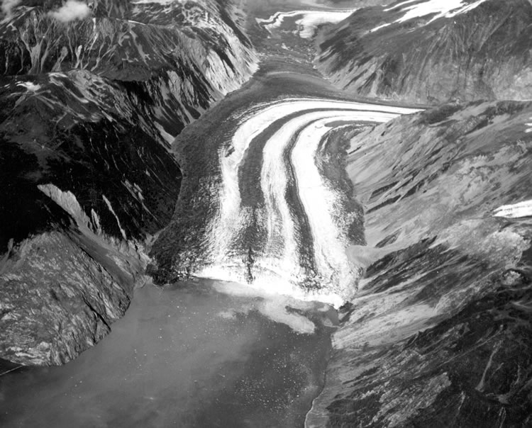
English: Photo looking down the Fairweather Fault Trench at the head of Lituya Bay. The front of Lituya Glacier with lateral and medial moraines is seen terminating in Gilbert Inlet. The cliff where the rockslide originated is on the right side of Gilbert Inlet. The opposite valley wall on the left side of Gilbert Inlet received the full force of the big wave, stripping it of soil and trees. Photo by D.J. Miller, United States Geological Survey. |
| Date | Summer 1958 |
| Source | USGS via [1] |
| Author | D.J. Miller, United States Geological Survey |
Licensing
[edit]
| This image or media file contains material based on a work of a United States Department of the Interior employee, created as part of that person's official duties. As a work of the U.S. federal government, such work is in the public domain in the United States. See the Department of the Interior copyright policy for more information. |  |
File history
Click on a date/time to view the file as it appeared at that time.
| Date/Time | Thumbnail | Dimensions | User | Comment | |
|---|---|---|---|---|---|
| current | 19:44, 16 July 2008 | | 750 × 604 (109 KB) | Eleland (talk | contribs) | == Summary == {{Information |Description={{en|1=Photo looking down the Fairweather Fault Trench at the head of Lituya Bay. The front of Lituya Glacier with lateral and medial moraines is seen terminating in Gilbert Inlet. The cliff where the rockslide ori |
You cannot overwrite this file.
File usage on Commons
The following 2 pages use this file:
File usage on other wikis
The following other wikis use this file:
- Usage on ceb.wikipedia.org
- Usage on cs.wikipedia.org
- Usage on fi.wikipedia.org
- Usage on fr.wikipedia.org
- Usage on he.wikipedia.org
- Usage on nn.wikipedia.org
- Usage on www.wikidata.org