File:Los Angeles River - flood of 1938 near Laurel Canyon Road (SPCOL26).jpg
Los_Angeles_River_-_flood_of_1938_near_Laurel_Canyon_Road_(SPCOL26).jpg (457 × 355 pixels, file size: 34 KB, MIME type: image/jpeg)
Captions
Captions
Summary[edit]
.jpg&action=edit§ion=1)
| Description |
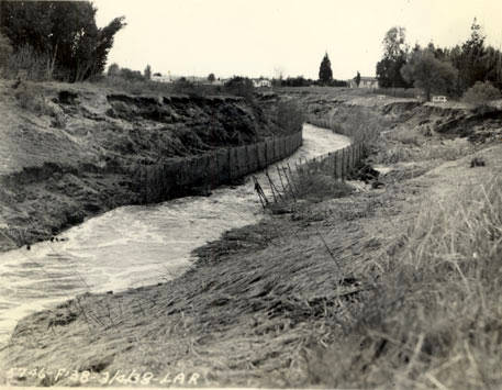
English: Los Angeles River - flood of 1938 near Laurel Canyon Road
Los Angeles River - Looking upstream from Laurel Canyon Avenue, showing wire and pipe protection which withstood the flood successfully. River mile 38.1. This image is from the Report on Engineering Aspects, Flood of March 1938 by the U. S. Engineer Office in Los Angeles and compiled in August 1938. The Los Angeles River and the river's tributaries flooded after a very wet rainy season and one particularly bad storm on March 1-3, 1938. The Report is a part of the Special Collections at CSU, Northridge and gives an extensive account of how different river channels reacted to the flood. After this flood, the Army Corps of Engineers set about insuring extensive flooding would not cause such extreme damage in the future. Image 29 in report. Black and white photograph. 3.5 x 4.5 in. |
| Date | |
| Source | http://digital-library.csun.edu/cdm/ref/collection/SFVH/id/3100 |
| Author | United States. Army. Corps of Engineers. Engineer Office |
| Camera location | | View this and other nearby images on: OpenStreetMap |
|---|
.jpg¶ms=034.147277_N_-118.392791_E_globe:Earth_type:camera__&language=en)
Licensing[edit]
.jpg&action=edit§ion=2)
This image or file is a work of a U.S. Army Corps of Engineers soldier or employee, taken or made as part of that person's official duties. As a work of the U.S. federal government, the image is in the public domain.
|
File history
Click on a date/time to view the file as it appeared at that time.
| Date/Time | Thumbnail | Dimensions | User | Comment | |
|---|---|---|---|---|---|
| current | 21:15, 15 June 2014 | | 457 × 355 (34 KB) | Junkyardsparkle (talk | contribs) | {{Information |Description={{en|''Los Angeles River - flood of 1938 near Laurel Canyon Road'' <p>Los Angeles River - Looking upstream from Laurel Canyon Avenue, showing wire and pipe protection wich withstood the flood successfully. River mile 38.1. Th... |
You cannot overwrite this file.
File usage on Commons
There are no pages that use this file.
File usage on other wikis
The following other wikis use this file:
- Usage on en.wikipedia.org
.jpg&oldid=684055881)