File:Lunga Point area chart prepared for landing on Guadalcanal 1942.jpg
Lunga_Point_area_chart_prepared_for_landing_on_Guadalcanal_1942.jpg (738 × 597 pixels, file size: 292 KB, MIME type: image/jpeg)
Captions
Captions
Summary[edit]
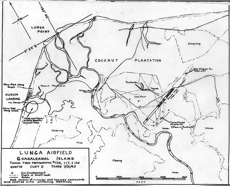
| DescriptionLunga Point area chart prepared for landing on Guadalcanal 1942.jpg | Annotated chart prepared for planning purposes shortly before the Lunga Point area, Guadalcanal Island, Solomon Islands, was captured by U.S. Marines on 7-8 August 1942. It is based on aerial photographs taken on 31 July 1942. The airfield then being constructed by the Japanese, which after changing hands became Henderson Field, is in the right center. |
| Date | |
| Source | Official U.S. Navy photo NH 97763 from the U.S. Navy Naval History and Heritage Command |
| Author | U.S. Navy |
| Other versions | File:Aerial reconnaissance photo of Lunga Point, Guadalcanal on 31 July 1942.jpg |
| Camera location | 9° 25′ 02.96″ S, 160° 01′ 56.82″ E | View this and other nearby images on: OpenStreetMap |
|---|
Licensing[edit]
| Public domainPublic domainfalsefalse |
This file is a work of a sailor or employee of the U.S. Navy, taken or made as part of that person's official duties. As a work of the U.S. federal government, it is in the public domain in the United States.
|
 | |
| This file has been identified as being free of known restrictions under copyright law, including all related and neighboring rights. | ||
https://creativecommons.org/publicdomain/mark/1.0/PDMCreative Commons Public Domain Mark 1.0falsefalse
File history
Click on a date/time to view the file as it appeared at that time.
| Date/Time | Thumbnail | Dimensions | User | Comment | |
|---|---|---|---|---|---|
| current | 14:29, 26 April 2015 |  | 738 × 597 (292 KB) | Cobatfor (talk | contribs) | == {{int:filedesc}} == {{Information |Description=Annotated chart prepared for planning purposes shortly before the Lunga Point area, Guadalcanal Island, Solomon Islands, was captured by U.S. Marines on 7-8 August 1942. It is based on aerial photograph... |
You cannot overwrite this file.
File usage on Commons
The following page uses this file:
Metadata
This file contains additional information such as Exif metadata which may have been added by the digital camera, scanner, or software program used to create or digitize it. If the file has been modified from its original state, some details such as the timestamp may not fully reflect those of the original file. The timestamp is only as accurate as the clock in the camera, and it may be completely wrong.
| Image title |
|
|---|---|
| Short title |
|
