File:MAP.USA Relief middle.jpg
Jump to navigation
Jump to search
No higher resolution available.
MAP.USA_Relief_middle.jpg (162 × 242 pixels, file size: 30 KB, MIME type: image/jpeg)
Captions
Captions
Add a one-line explanation of what this file represents
Summary[edit]
| Description |
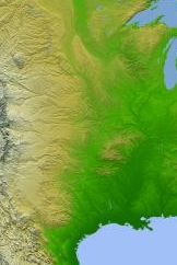
English: NASA - Jet Propulsion LabPIA03377: Shaded Relief with Height as Color, North America Target Name: Earth
Is a satellite of: Sol (our sun) Mission: Shuttle Radar Topography Mission (SRTM) Spacecraft: Space Shuttle Endeavour Instrument: C-Band Interferometric Radar Product Size: 9600 samples x 7240 lines Produced By: JPL |
| Source | NASA |
| Author | NASA. Cropped by User:Andrew Dalby |
Licensing[edit]
| This file is in the public domain in the United States because it was solely created by NASA. NASA copyright policy states that "NASA material is not protected by copyright unless noted". (See Template:PD-USGov, NASA copyright policy page or JPL Image Use Policy.) | ||
 |
Warnings:
|
File history
Click on a date/time to view the file as it appeared at that time.
| Date/Time | Thumbnail | Dimensions | User | Comment | |
|---|---|---|---|---|---|
| current | 13:33, 18 August 2016 | | 162 × 242 (30 KB) | Andrew Dalby (talk | contribs) | == {{int:filedesc}} == {{Information |Description={{en|1=NASA - Jet Propulsion LabPIA03377: Shaded Relief with Height as Color, North America Target Name: Earth Is a satellite of: Sol (our sun) Mission: Shuttle Radar Topography Mission (SRTM) Space... |
You cannot overwrite this file.
File usage on Commons
There are no pages that use this file.
File usage on other wikis
The following other wikis use this file:
- Usage on la.wikipedia.org