File:Map of comune of Valsavarenche (region Aosta Valley, Italy).svg
Jump to navigation
Jump to search

Size of this PNG preview of this SVG file: 522 × 343 pixels. Other resolutions: 320 × 210 pixels | 640 × 421 pixels | 1,024 × 673 pixels | 1,280 × 841 pixels | 2,560 × 1,682 pixels.
Original file (SVG file, nominally 522 × 343 pixels, file size: 138 KB)
Captions
Captions
Add a one-line explanation of what this file represents
Summary[edit]
.svg&action=edit§ion=1)
| Description |
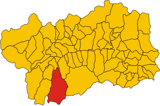
English: Map of the municipality (comune) of Valsavarenche (comune, Italy) (region Aosta Valley, Italy) |
| Date | |
| Source | Own work |
| Author | Vonvikken |
| SVG development | This W3C-invalid locator map was created with Inkscape. |
Licensing[edit]
.svg&action=edit§ion=2)
| I, the copyright holder of this work, release this work into the public domain. This applies worldwide. In some countries this may not be legally possible; if so: I grant anyone the right to use this work for any purpose, without any conditions, unless such conditions are required by law. |
File history
Click on a date/time to view the file as it appeared at that time.
| Date/Time | Thumbnail | Dimensions | User | Comment | |
|---|---|---|---|---|---|
| current | 14:29, 7 June 2010 | | 522 × 343 (138 KB) | File Upload Bot (Vonvikken) (talk | contribs) | == {{int:filedesc}} == {{Information |Description={{DescrMapComuneItaly|Valsavarenche|||AO}} |Source={{own}} |Author=Vonvikken |Date=2010-06-07 |Permission= }} {{inkscape}} == {{int:license}} == {{PD-self}} |
You cannot overwrite this file.
File usage on Commons
The following 3 pages use this file:
File usage on other wikis
The following other wikis use this file:
- Usage on als.wikipedia.org
- Usage on ar.wikipedia.org
- Usage on bg.wikipedia.org
- Usage on ca.wikipedia.org
- Usage on ceb.wikipedia.org
- Usage on el.wikipedia.org
- Usage on es.wikipedia.org
- Usage on eu.wikipedia.org
- Usage on fr.wikipedia.org
- Usage on hu.wikipedia.org
- Usage on ia.wikipedia.org
- Usage on it.wikipedia.org
- Usage on ja.wikipedia.org
- Usage on la.wikipedia.org
- Usage on lij.wikipedia.org
- Usage on lmo.wikipedia.org
- Usage on pms.wikipedia.org
- Usage on pt.wikipedia.org
- Usage on ro.wikipedia.org
- Usage on sv.wikipedia.org
- Usage on tr.wikipedia.org
- Usage on tt.wikipedia.org
- Usage on vi.wikipedia.org
- Usage on www.wikidata.org
.svg&oldid=729517495)