File:Map-etno-tiflis.jpg
Jump to navigation
Jump to search
Size of this preview: 800 × 461 pixels. Other resolutions: 320 × 184 pixels | 640 × 369 pixels | 1,024 × 590 pixels | 1,280 × 738 pixels | 2,560 × 1,475 pixels | 5,900 × 3,400 pixels.
Original file (5,900 × 3,400 pixels, file size: 3.77 MB, MIME type: image/jpeg)
Captions
Captions
Add a one-line explanation of what this file represents
|
|
|
|
-map_legend-3.jpg)
-map_legend-1.jpg)
-map_legend-2.jpg)
Summary
[edit]| Description |
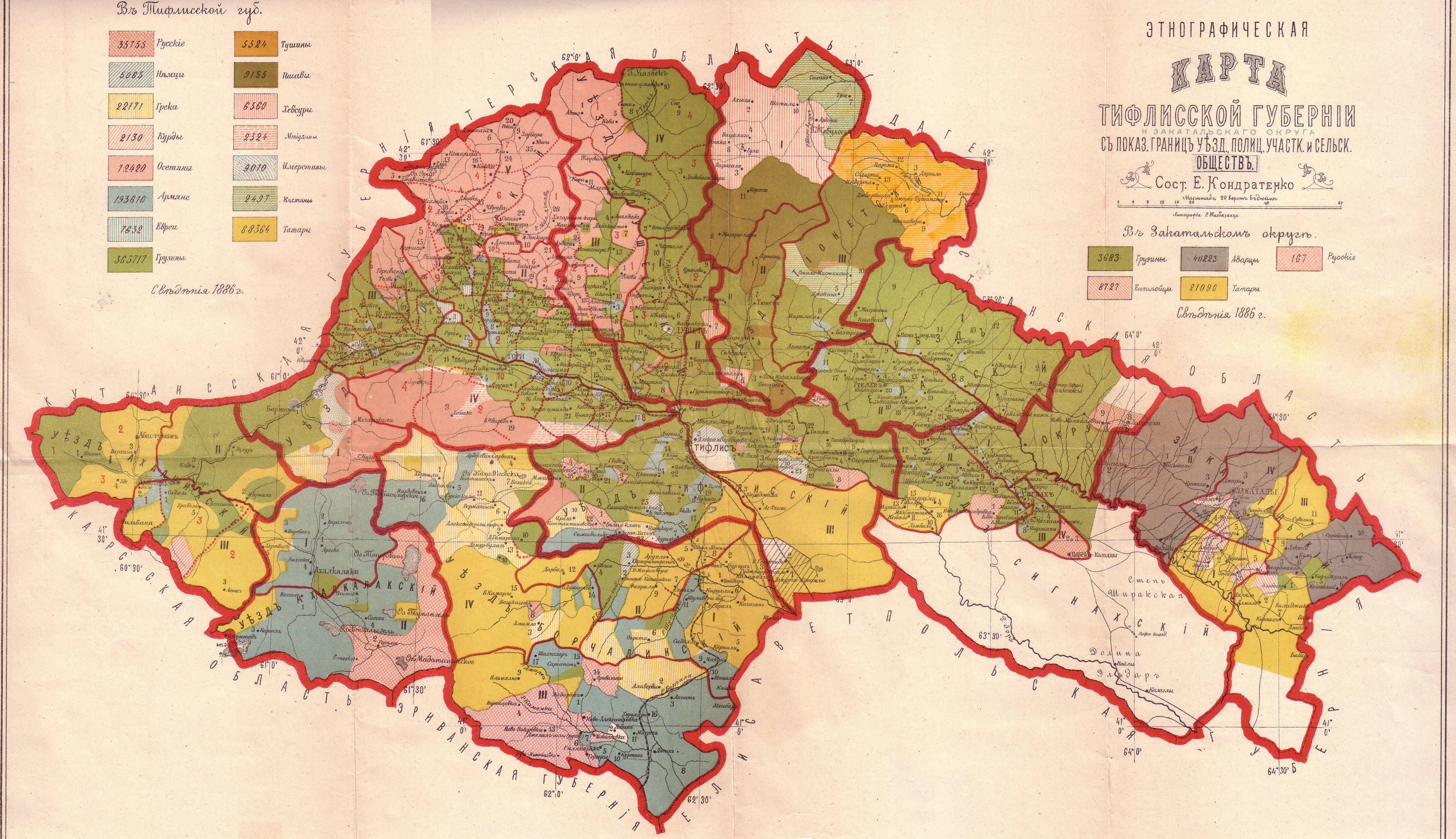
English: Ethnographic map of the Tiflis Governorate Русский: Этнографическая карта Тифлисской губернии |
| Date | (according to the census of 1886) |
| Source |
Русский: Сборникь Статистическихь свѣдѣній по Закавказскому краю. Составлень, по постановленію Закавказскаго Статистическаго Комитета, состоящимь при немь Отделомь, подь редакціей старшаго редактора отдела Е. Кондратенко. Часть 1. ( с картами Елисаветопольский уезд, 20 верст в дюйме, этнографические:Бакинская губерния, Дагестанская область,Карсская область,Тифлисская губерния,Черноморская губерния,Эриванская губерния) Тифлись, 1902 г.
|
| Author |
Русский: Е.И. Кондратенко |
| Permission (Reusing this file) |
Disclaimer |
| Other versions |
|


.jpg)
Licensing
[edit]
|
This is a faithful photographic reproduction of a two-dimensional, public domain work of art. The work of art itself is in the public domain for the following reason:
The official position taken by the Wikimedia Foundation is that "faithful reproductions of two-dimensional public domain works of art are public domain".
This photographic reproduction is therefore also considered to be in the public domain in the United States. In other jurisdictions, re-use of this content may be restricted; see Reuse of PD-Art photographs for details. | ||||
File history
Click on a date/time to view the file as it appeared at that time.
| Date/Time | Thumbnail | Dimensions | User | Comment | |
|---|---|---|---|---|---|
| current | 12:43, 28 February 2010 | | 5,900 × 3,400 (3.77 MB) | Kober (talk | contribs) | {{Information |Description={{en|1=Ethnographic map of the Tiflis Governorate}} |Source=[http://ikalto.com/index-maps.php Ikalto.com] from Кавказскій календарь, Тифлисъ, 1902 |Author=E. Kondratenko |Date=1902 |Permission= |other_v |
You cannot overwrite this file.
File usage on Commons
The following 11 pages use this file:
- Atlas of Georgia
- Atlas of South Ossetia
- File:Ethnographic map of the Akhalkalaki uyezd-1902.jpg
- File:Ethnographic map of the Akhaltsikhe uyezd-1902.jpg
- File:Ethnographic map of the Borjomi uyezd-1902.jpg
- File:Ethnographic map of the Signakhi uyezd-1902.jpg
- File:Ethnographic map of the Tiflis Governorate (1902)-map legend-1.jpg
- File:Ethnographic map of the Tiflis Governorate (1902)-map legend-2.jpg
- File:Ethnographic map of the Tiflis Governorate (1902)-map legend-3.jpg
- File:Ethnographic map of the Tiflis uyezd-1902.jpg
- File:Map-etno-tiflis (A).jpg
File usage on other wikis
The following other wikis use this file:
- Usage on az.wikipedia.org
- Usage on de.wikipedia.org
- Usage on es.wikipedia.org
- Usage on fr.wikipedia.org
- Usage on hy.wikipedia.org
- Usage on id.wikipedia.org
- Usage on ka.wikipedia.org
- Usage on nl.wikipedia.org
- Zuid-Ossetië
- Gouvernement Tiflis
- Gori (gemeente)
- Kaspi (gemeente)
- Kareli (gemeente)
- Chasjoeri (gemeente)
- Achalgori (gemeente)
- Achmeta (gemeente)
- Dmanisi (gemeente)
- Doesjeti (gemeente)
- Mtscheta (gemeente)
- Kazbegi (gemeente)
- Kvareli (gemeente)
- Sagaredzjo (gemeente)
- Telavi (gemeente)
- Tianeti (gemeente)
- Tsalka (gemeente)
- Troesovallei
- Gebruiker:Lidewij C J./ Zoeken
- Usage on ru.wikipedia.org
- Usage on uk.wikipedia.org
- Usage on xmf.wikipedia.org