File:Map - Special Collections University of Amsterdam - OTM- HB-KZL 31-08-28.tif
Jump to navigation
Jump to search

Size of this JPG preview of this TIF file: 711 × 599 pixels. Other resolutions: 285 × 240 pixels | 570 × 480 pixels | 911 × 768 pixels | 1,215 × 1,024 pixels | 2,430 × 2,048 pixels | 7,908 × 6,665 pixels.
Original file (7,908 × 6,665 pixels, file size: 150.8 MB, MIME type: image/tiff)
Captions
Captions
Add a one-line explanation of what this file represents
Summary[edit]
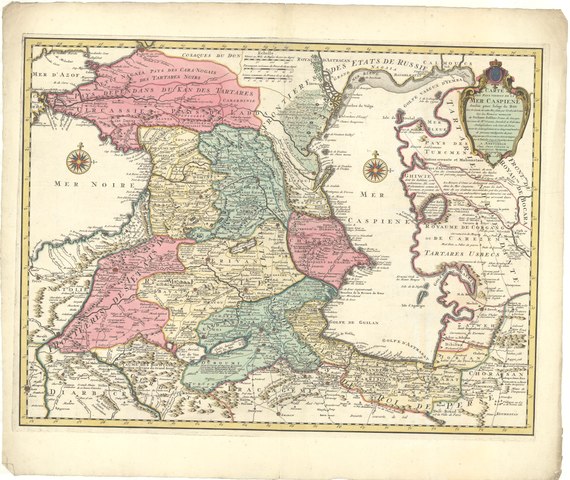
| Carte des pays voisins de la Mer Caspiene : dressée pour l’usage du roy sur la carte de cette mer faite par l’ordre du czar / ... par G. Delisle geog. de l’Acad. Roy des Scien[ces]
( |
|||||||||||||||||||||||||||
|---|---|---|---|---|---|---|---|---|---|---|---|---|---|---|---|---|---|---|---|---|---|---|---|---|---|---|---|
| Author |
Guillaume Delisle (1675-1726) |
||||||||||||||||||||||||||
| Title |
Carte des pays voisins de la Mer Caspiene : dressée pour l’usage du roy sur la carte de cette mer faite par l’ordre du czar / ... par G. Delisle geog. de l’Acad. Roy des Scien[ces] |
||||||||||||||||||||||||||
| Date | [after 1757] | ||||||||||||||||||||||||||
| Medium | Copperplate print | ||||||||||||||||||||||||||
| Dimensions | height: 45.5 cm (17.9 in); width: 60.6 cm (23.8 in) | ||||||||||||||||||||||||||
| Collection |
|
||||||||||||||||||||||||||
| Accession number |
OTM: HB-KZL 31-08-28 |
||||||||||||||||||||||||||
| Place of creation | Amsterdam, published and printed by Johannes Covens (1720-1772) and Cornelis Mortier (1720-1772) | ||||||||||||||||||||||||||
| Notes | This object is part of the collection of the Koninklijk Nederlands Aardrijkskundig Genootschap (KNAG) | ||||||||||||||||||||||||||
| Source/Photographer |
|
||||||||||||||||||||||||||
| Permission (Reusing this file) |
|
||||||||||||||||||||||||||

[[Category:]Map collection Frederik Muller & Co]]
File history
Click on a date/time to view the file as it appeared at that time.
| Date/Time | Thumbnail | Dimensions | User | Comment | |
|---|---|---|---|---|---|
| current | 14:47, 20 March 2018 |  | 7,908 × 6,665 (150.8 MB) | DeJong2332 (talk | contribs) | pattypan 18.02 |
You cannot overwrite this file.
File usage on Commons
The following page uses this file: