File:Map of Brown Co, Ks, USA.png
跳转到导航
跳转到搜索
本预览的尺寸:641 × 600像素。 其他分辨率:257 × 240像素 | 513 × 480像素 | 900 × 842像素。
原始文件 (900 × 842像素,文件大小:354 KB,MIME类型:image/png)
说明
说明
添加一行文字以描述该文件所表现的内容
摘要
[编辑]
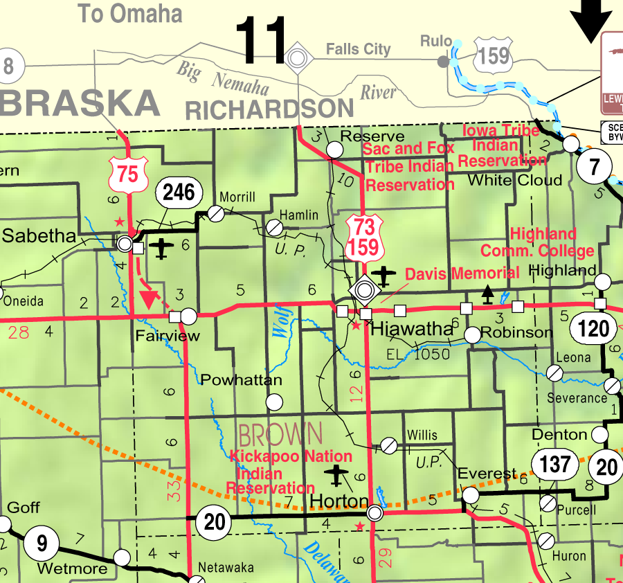
| 描述 | This map of Brown County, Kansas, USA, is copied at a resolution of 300 pixels/inch from the original PDF file. |
| 日期 | |
| 来源 | Kansas 2005–2006 Official Transportation Map [1] (map legend) |
| 作者 | Designed and published by the Kansas Department of Transportation. |
| 授权 (二次使用本文件) |
许可协议
[编辑]
| 本作品已被作者Kansas Department of Transportation释出到公有领域。这适用于全世界。 在一些国家这可能不合法;如果是这样的话,那么: Kansas Department of Transportation无条件地授予任何人以任何目的使用本作品的权利,除非这些条件是法律规定所必需的。
|
This map is published by the Kansas Department of Transportation and is distributed to the public free of charge. KDOT makes no warranties, guarantees, or representations for accuracy of this information and assumes no liability for errors or omissions. Maps produced using tax payer dollars are free for public use.
文件历史
点击某个日期/时间查看对应时刻的文件。
| 日期/时间 | 缩略图 | 大小 | 用户 | 备注 | |
|---|---|---|---|---|---|
| 当前 | 2006年2月20日 (一) 05:02 | | 900 × 842(354 KB) | Moverton(留言 | 贡献) | Source: Kansas 2005-2006 Official Transportation Map {{PD-US}} |
您不可以覆盖此文件。
文件用途
没有页面使用本文件。
全域文件用途
以下其他wiki使用此文件:
- arz.wikipedia.org上的用途
- azb.wikipedia.org上的用途
- en.wikipedia.org上的用途
- Brown County, Kansas
- Everest, Kansas
- Fairview, Kansas
- Hamlin, Kansas
- Hiawatha, Kansas
- Horton, Kansas
- Morrill, Kansas
- Powhattan, Kansas
- Reserve, Kansas
- Robinson, Kansas
- Willis, Kansas
- Kickapoo Site 1, Kansas
- Kickapoo Site 2, Kansas
- Kickapoo Site 5, Kansas
- Kickapoo Site 6, Kansas
- Kickapoo Site 7, Kansas
- Kickapoo Tribal Center, Kansas
- nl.wikipedia.org上的用途
- simple.wikipedia.org上的用途
- sr.wikipedia.org上的用途
- ur.wikipedia.org上的用途
- zh.wikipedia.org上的用途