File:Map of hazari detailed.jpg
Jump to navigation
Jump to search

Size of this preview: 800 × 569 pixels. Other resolutions: 320 × 228 pixels | 640 × 455 pixels | 1,024 × 729 pixels | 1,280 × 911 pixels | 2,777 × 1,976 pixels.
Original file (2,777 × 1,976 pixels, file size: 996 KB, MIME type: image/jpeg)
Captions
Captions
Add a one-line explanation of what this file represents
Summary[edit]
| Description |
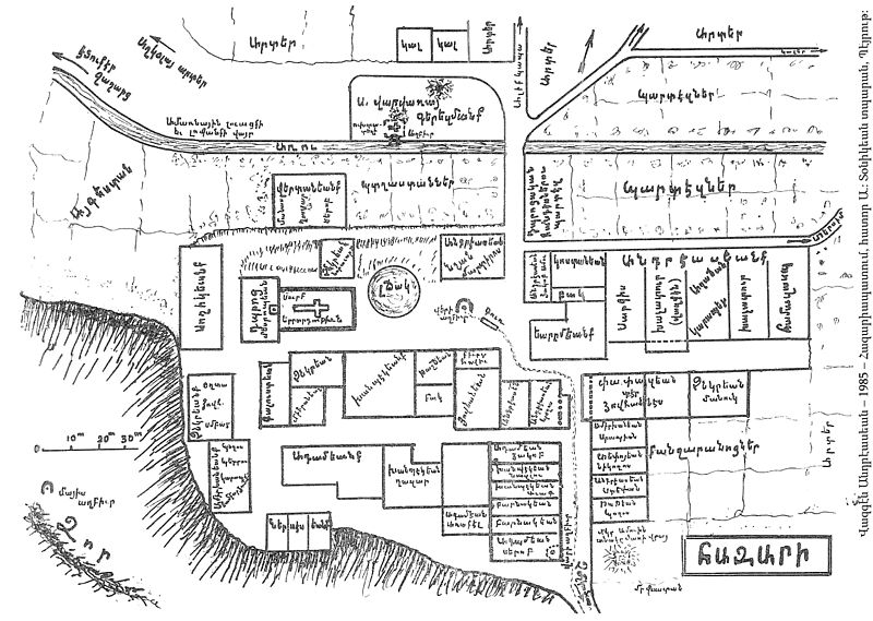
English: Map of the Armenian village of Hazari, located near the town of Tchmchgadzak (now Cemisgezek), drawn by Vazken Andréassian (1903-1995) Français : Plan de Hazari, village arménien situé près de la ville de Tchmchgadzak (now Cemisgezek), dessiné par Vazken Andréassian (1903-1995) Հայերեն: Հազարի գիւղի յատակագիծը: Կազմեց՟ Վազգէն Անդրէասեան (1903-1995) |
| Date | |
| Source | Own work |
| Author | Vazken |
Licensing[edit]
I, the copyright holder of this work, hereby publish it under the following license:
This file is licensed under the Creative Commons Attribution-Share Alike 3.0 Unported license.
- You are free:
- to share – to copy, distribute and transmit the work
- to remix – to adapt the work
- Under the following conditions:
- attribution – You must give appropriate credit, provide a link to the license, and indicate if changes were made. You may do so in any reasonable manner, but not in any way that suggests the licensor endorses you or your use.
- share alike – If you remix, transform, or build upon the material, you must distribute your contributions under the same or compatible license as the original.
File history
Click on a date/time to view the file as it appeared at that time.
| Date/Time | Thumbnail | Dimensions | User | Comment | |
|---|---|---|---|---|---|
| current | 22:33, 31 January 2013 | | 2,777 × 1,976 (996 KB) | Vazken (talk | contribs) | User created page with UploadWizard |
You cannot overwrite this file.
File usage on Commons
There are no pages that use this file.
File usage on other wikis
The following other wikis use this file:
- Usage on hy.wikipedia.org
- Usage on hyw.wikipedia.org
- Usage on tr.wikipedia.org