File:Map of invasion of Yugoslavia - Northeastern section map.svg
Jump to navigation
Jump to search

Size of this PNG preview of this SVG file: 800 × 507 pixels. Other resolutions: 320 × 203 pixels | 640 × 406 pixels | 1,024 × 649 pixels | 1,280 × 811 pixels | 2,560 × 1,623 pixels | 1,420 × 900 pixels.
Original file (SVG file, nominally 1,420 × 900 pixels, file size: 4.57 MB)
Captions
Captions
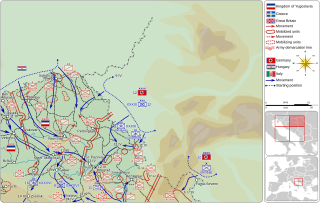
Northeastern section of Map of invasion of Yugoslavia, Invasion of Yugoslavia, the April War, 1941.
Summary[edit]
| Description |
English: The map shows northeastern section of Map of invasion of Yugoslavia. |
|||
| Date | ||||
| Source |
Own work
Derived from; Information from:
|
|||
| Author | Goran tek-en, following request by and knowledge from Kaštel Stari | |||
| Permission (Reusing this file) |
This file is licensed under the Creative Commons Attribution-Share Alike 4.0 International license. Attribution: Goran tek-en
|
|||
| Other versions |
|
|||
| SVG development |


_location_map.svg)
| Object location | | View this and other nearby images on: OpenStreetMap |
|---|
File history
Click on a date/time to view the file as it appeared at that time.
| Date/Time | Thumbnail | Dimensions | User | Comment | |
|---|---|---|---|---|---|
| current | 15:32, 24 May 2020 | | 1,420 × 900 (4.57 MB) | Goran tek-en (talk | contribs) | {{Information |description ={{en|1=The map shows northeastern section of Map of invasion of Yugoslavia.}} |date =20200524 |source ={{Own}}<br> {{Derived from|Map of invasion of Yugoslavia - Situation map.svg|Yugoslavia (1939–41) location map.svg|NATO_Map_Symbol_-_Motorised_Infantry.svg}} Derived from; * [https://www.openstreetmap.org/#map=9/46.1189/19.9855&layers=T OSM] Information from: * Vojna enciklopedija, editor Nikola Gažević, pages 186-187. * {{U|Kaštel Stari}}... |
You cannot overwrite this file.
File usage on Commons
The following 6 pages use this file:
- User:Goran tek-en/Gallery/2020
- User:Magog the Ogre/Maps of conflicts/2020 May
- File:Map of invasion of Yugoslavia - Northwestern section map.svg
- File:Map of invasion of Yugoslavia - Situation map.svg
- File:Map of invasion of Yugoslavia - Southeastern section map.svg
- File:Map of invasion of Yugoslavia - Southwestern section map.svg
File usage on other wikis
The following other wikis use this file:
- Usage on hr.wikipedia.org