File:Map of the United States - exhibiting the post-roads, the situations, connecions & distances of the post-offices, stage roads, counties, ports of entry and delivery for foreign vessels, and (NYPL b15519021-1261072a).tiff

Original file (3,744 × 6,219 pixels, file size: 66.63 MB, MIME type: image/tiff)
Captions
Captions
Summary[edit]
| Description |
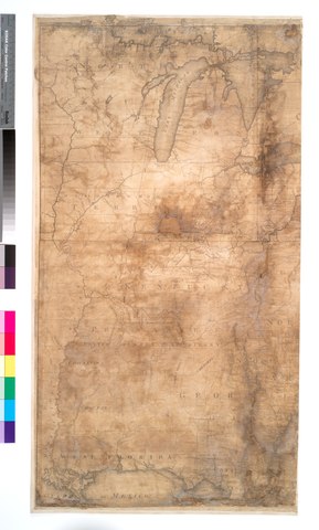
English: * "Deposited as the Act directs September 26th 1796."
|
||
| Title | Map of the United States : exhibiting the post-roads, the situations, connecions & distances of the post-offices, stage roads, counties, ports of entry and delivery for foreign vessels, and the principal rivers | ||
| Alternative title | Map of the United States exhibiting post roads and distances : the first sheet comprehending the nine northern states, with parts of Virginia and the territory north of Ohio | ||
| Date | |||
| Source | https://digitalcollections.nypl.org/items/951b01f6-3c0e-4492-e040-e00a18065cf4 | ||
| Author | Scan by NYPL | ||
| Permission (Reusing this file) |
|
||
| Other versions |
|
||
| UUID | c1397ac0-c52a-012f-f357-3c075448cc4b | ||
| MODS | http://api.repo.nypl.org/api/v1/items/mods/951b01f6-3c0e-4492-e040-e00a18065cf4 | ||
| Origin place | [Philadelphia?] | ||
| Image ID | 1261072a | ||
| Collection | Maps of North America | ||
| Collection UUID | 951b01f6-3c0e-4492-e040-e00a18065cf4 | ||
| NYPL catalog ID | b15519021 | ||
| NYPL Division | Lionel Pincus and Princess Firyal Map Division | ||
| Topics | Post roads |


|
The categories of this image need checking. You can do so here.
|
Licensing[edit]
This image is in the public domain because it is a mere mechanical scan or photocopy of a public domain original, or – from the available evidence – is so similar to such a scan or photocopy that no copyright protection can be expected to arise. The original itself is in the public domain for the following reason:
This tag is designed for use where there may be a need to assert that any enhancements (eg brightness, contrast, colour-matching, sharpening) are in themselves insufficiently creative to generate a new copyright. It can be used where it is unknown whether any enhancements have been made, as well as when the enhancements are clear but insufficient. For known raw unenhanced scans you can use an appropriate {{PD-old}} tag instead. For usage, see Commons:When to use the PD-scan tag.  | ||||
File history
Click on a date/time to view the file as it appeared at that time.
| Date/Time | Thumbnail | Dimensions | User | Comment | |
|---|---|---|---|---|---|
| current | 23:24, 8 July 2016 |  | 3,744 × 6,219 (66.63 MB) | Fæ (talk | contribs) | NYPL maps http://digitalcollections.nypl.org/items/951b01f6-3c0e-4492-e040-e00a18065cf4, part of User:Fæ/Project list/NYPL T318.879 |
You cannot overwrite this file.
File usage on Commons
The following 2 pages use this file:
- File:Map of the United States - exhibiting the post-roads, the situations, connecions & distances of the post-offices, stage roads, counties, ports of entry and delivery for foreign vessels, and (NYPL b15519021-1261072).tiff
- File:Map of the United States - exhibiting the post-roads, the situations, connecions & distances of the post-offices, stage roads, counties, ports of entry and delivery for foreign vessels, and (NYPL b15519021-1261072b).tiff