File:Mercator scale plot.svg
Jump to navigation
Jump to search

Size of this PNG preview of this SVG file: 132 × 233 pixels. Other resolutions: 136 × 240 pixels | 272 × 480 pixels | 435 × 768 pixels | 580 × 1,024 pixels | 1,160 × 2,048 pixels.
Original file (SVG file, nominally 132 × 233 pixels, file size: 47 KB)
Captions
Captions
Add a one-line explanation of what this file represents
Summary[edit]
| Description |
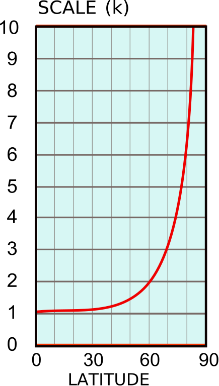
English: The scale factor as a function of latitude in the Mercator projection. |
| Date | |
| Source | Own work |
| Author | Peter Mercator |
Licensing[edit]
| I, the copyright holder of this work, release this work into the public domain. This applies worldwide. In some countries this may not be legally possible; if so: I grant anyone the right to use this work for any purpose, without any conditions, unless such conditions are required by law. |
File history
Click on a date/time to view the file as it appeared at that time.
| Date/Time | Thumbnail | Dimensions | User | Comment | |
|---|---|---|---|---|---|
| current | 10:44, 6 August 2010 | | 132 × 233 (47 KB) | Peter Mercator (talk | contribs) | {{Information |Description={{en|1=The scale factor as a function of latitude in the Mercator projection.}} |Source={{own}} |Author=Peter Mercator |Date=2010-08-06 |Permission= |other_versions= }} Category:Map projections |
You cannot overwrite this file.
File usage on Commons
There are no pages that use this file.
File usage on other wikis
The following other wikis use this file:
- Usage on en.wikipedia.org
- Usage on en.wikibooks.org