File:Mezoregiony Kondrackiego.png
Jump to navigation
Jump to search

Size of this preview: 669 × 599 pixels. Other resolutions: 268 × 240 pixels | 536 × 480 pixels | 858 × 768 pixels | 1,143 × 1,024 pixels | 2,287 × 2,048 pixels | 3,389 × 3,035 pixels.
Original file (3,389 × 3,035 pixels, file size: 5.71 MB, MIME type: image/png)
Captions
Captions
Add a one-line explanation of what this file represents
Summary[edit]
JPG Version: Image:Mezoregiony Kondrackiego.jpg
Another Version: Image:Regiony Kondrackiego-hipsometria.png
| Description |
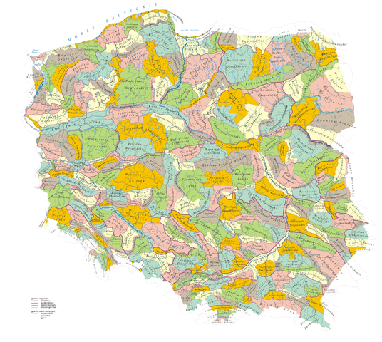
Polski: Polska: mezoregiony fizycznogeograficzne na tle podziału administracyjnego
English: Poland: Physico-geographical mezoregions of Poland overlaid with the administrative division |
| Source | Praca własna na podstawie: 1) granice mezoregionów: J. Kondracki, A. Richling Regiony Fizycznogeograficzne 1:1.500.000 [w:] Atlas Rzeczypospolitej Polskiej, Główny Geodeta Kraju, Warszawa 1994; 2) hydrografia: Atlas świata, Służba Topograficzna Wojska Polskiego, Warszawa 1962 z naniesionymi aktualizacjami z różnych źródeł; 3) podział administracyjny – Mapa Administracyjna Rzeczypospolitej Polskiej 1:500.000, Główny Geodeta Kraju, Warszawa 2003 z naniesionymi aktualizacjami |
| Author | Aotearoa |
Licensing[edit]
I, the copyright holder of this work, hereby publish it under the following licenses:

|
Permission is granted to copy, distribute and/or modify this document under the terms of the GNU Free Documentation License, Version 1.2 or any later version published by the Free Software Foundation; with no Invariant Sections, no Front-Cover Texts, and no Back-Cover Texts. A copy of the license is included in the section entitled GNU Free Documentation License. |
| This file is licensed under the Creative Commons Attribution-Share Alike 3.0 Unported license. | ||
| ||
| This licensing tag was added to this file as part of the GFDL licensing update. |
You may select the license of your choice.
File history
Click on a date/time to view the file as it appeared at that time.
| Date/Time | Thumbnail | Dimensions | User | Comment | |
|---|---|---|---|---|---|
| current | 08:04, 11 February 2008 | | 3,389 × 3,035 (5.71 MB) | Aotearoa (talk | contribs) | |
| 14:46, 6 May 2007 |  | 3,389 × 3,035 (6.9 MB) | Aotearoa (talk | contribs) | ||
| 14:27, 6 May 2007 |  | 3,389 × 3,035 (7.31 MB) | Aotearoa (talk | contribs) | {{Information |Description=Polska: mezoregiony fizycznogeograficzne na tle podziału administracyjnego (''Physico-geographical mezoregions of Poland'') |Source=self-made |Date= |Author= Aotearoa }} |
You cannot overwrite this file.
File usage on Commons
The following 4 pages use this file:
File usage on other wikis
The following other wikis use this file:
- Usage on bg.wikipedia.org
- Usage on cs.wikipedia.org
- Usage on de.wikipedia.org
- Usage on en.wikipedia.org
- Usage on pl.wikipedia.org
- Usage on sk.wikipedia.org
- Usage on uk.wikipedia.org