File:Municipios y zonas de Gran Canaria.svg
Jump to navigation
Jump to search

Size of this PNG preview of this SVG file: 800 × 600 pixels. Other resolutions: 320 × 240 pixels | 640 × 480 pixels | 1,024 × 768 pixels | 1,280 × 960 pixels | 2,560 × 1,920 pixels.
Original file (SVG file, nominally 1,024 × 768 pixels, file size: 36 KB)
Captions
Captions
Add a one-line explanation of what this file represents
Summary[edit]
| Description |
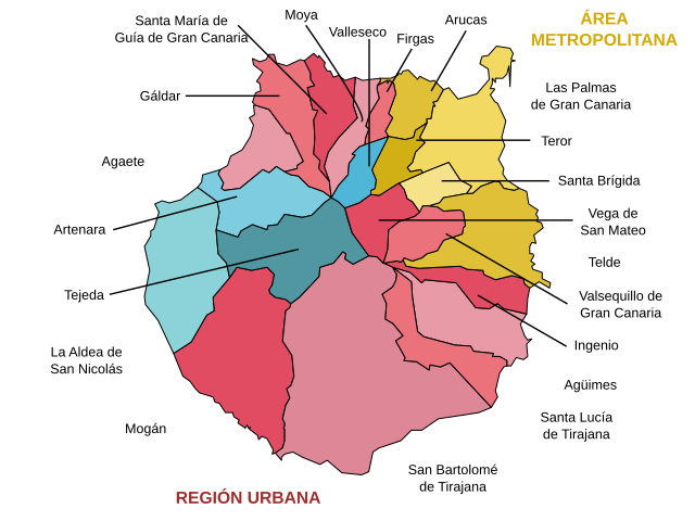
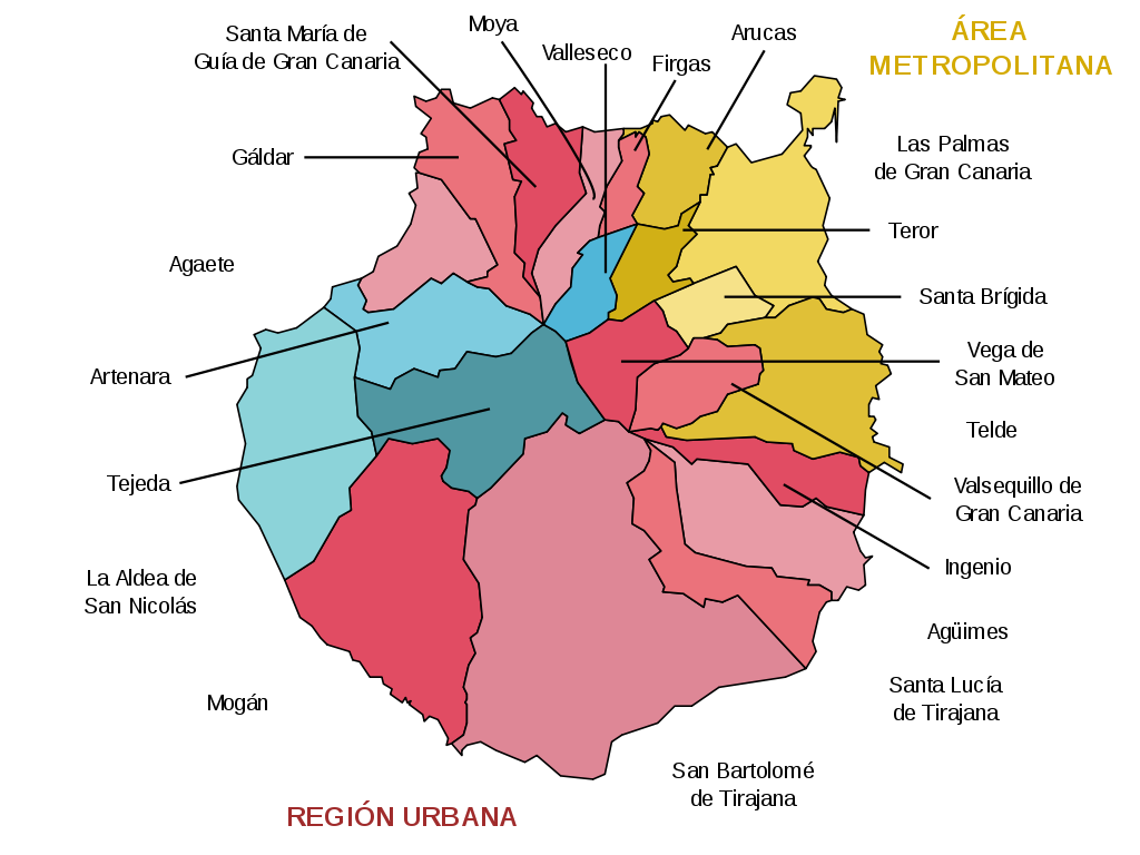
English: Map with the marked place names of the municipalities and areas of the island of Gran Canaria (Canary Islands, Spain).
Español: Mapa con los topónimos marcados de los municipios y zonas de la isla de Gran Canaria (Islas Canarias, España). |
| Date | |
| Source | Own work |
| Author | HansenBCN |
| SVG development |
Licensing[edit]
I, the copyright holder of this work, hereby publish it under the following licenses:

|
Permission is granted to copy, distribute and/or modify this document under the terms of the GNU Free Documentation License, Version 1.2 or any later version published by the Free Software Foundation; with no Invariant Sections, no Front-Cover Texts, and no Back-Cover Texts. A copy of the license is included in the section entitled GNU Free Documentation License. |
| This file is licensed under the Creative Commons Attribution-Share Alike 3.0 Unported license. | ||
| ||
| This licensing tag was added to this file as part of the GFDL licensing update. |
You may select the license of your choice.
File history
Click on a date/time to view the file as it appeared at that time.
| Date/Time | Thumbnail | Dimensions | User | Comment | |
|---|---|---|---|---|---|
| current | 14:14, 20 October 2007 | | 1,024 × 768 (36 KB) | Edub (talk | contribs) | |
| 18:29, 15 September 2007 |  | 1,024 × 768 (36 KB) | HansenBCN (talk | contribs) | == Summary == {{Information |Description= {{ca|Mapa amb els topònims i zones de l'illa de Gran Canària (Illes Canàries)}} {{es|Mapa con los topónimos marcados de los municipios y zonas de la isla de Gran Canaria (Islas Canarias)}} {{en|Labeled map wit | |
| 14:23, 14 September 2007 |  | 1,024 × 768 (36 KB) | HansenBCN (talk | contribs) | == Summary == {{Information |Description= {{ca|Mapa amb els topònims i zones de l'illa de Gran Canària (Illes Canàries)}} {{es|Mapa con los topónimos marcados de los municipios y zonas de la isla de Gran Canaria (Islas Canarias)}} {{en|Labeled map wit |
You cannot overwrite this file.
File usage on Commons
The following 2 pages use this file:
File usage on other wikis
The following other wikis use this file:
- Usage on az.wikipedia.org
- Usage on be.wikipedia.org
- Usage on br.wikipedia.org
- Usage on cs.wikipedia.org
- Usage on de.wikipedia.org
- Usage on en.wikipedia.org
- Las Palmas
- Gran Canaria
- Arguineguín
- List of municipalities in Las Palmas
- Mogán
- Santa María de Guía de Gran Canaria
- Agaete
- Firgas
- Santa Brígida, Las Palmas
- Telde
- Vega de San Mateo
- Valsequillo de Gran Canaria
- Ingenio, Las Palmas
- Agüimes
- Santa Lucía de Tirajana
- San Bartolomé de Tirajana
- La Aldea de San Nicolás
- Tejeda
- Artenara
- Gáldar
- Gran Canaria Airport
- Moya, Las Palmas
- Valleseco
- Arucas, Las Palmas
- Fataga
- UD Las Palmas
- San Agustin, Las Palmas
- Maspalomas
- Roque Nublo
- Playa del Inglés
- Autopista GC-1
- Autovía GC-2
- Puerto Rico de Gran Canaria
- Puerto de Mogán
- Universidad de Las Palmas CF
- Gran Canaria giant rat
- Teror
- Fuente de los Azulejos
- Estadio Gran Canaria
- CB Gran Canaria
- UD Vecindario
- Castillo CF
- Bandama Caldera
- Sonnenland
- Maspalomas Station
View more global usage of this file.