File:NO road sign 149.svg
Aller à la navigation
Aller à la recherche

Taille de cet aperçu PNG pour ce fichier SVG : 319 × 280 pixels. Autres résolutions : 273 × 240 pixels | 547 × 480 pixels | 875 × 768 pixels | 1 167 × 1 024 pixels | 2 333 × 2 048 pixels.
Fichier d’origine (Fichier SVG, nominalement de 319 × 280 pixels, taille : 8 kio)
Légendes
Légendes
Ajoutez en une ligne la description de ce que représente ce fichier
Description
[modifier]
| Description |
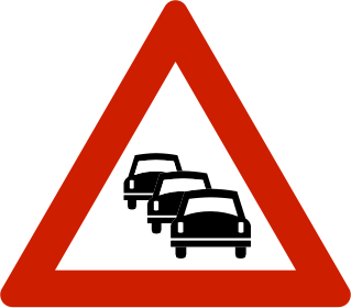
English: Norwegian road sign 149.0.
Norsk bokmål: Norsk veiskilt 149.0. |
| Date | 10 juillet 2008 (date de téléversement) |
| Source | EPS file downloaded from the Norwegian Public Roads Administration (Statens vegvesen) website: http://www.vegvesen.no/vegskilt/filnedlasting.stm |
| Auteur | Peter J. Acklam converted the original EPS file to PDF with Ghostscript and the PDF file to SVG with Inkscape. |
Conditions d’utilisation
[modifier]
| This image is in the public domain because it depicts a Norwegian road sign, produced by the The Norwegian Public Roads Administration (Statens vegvesen). The image may be used freely. |  |
Historique du fichier
Cliquer sur une date et heure pour voir le fichier tel qu'il était à ce moment-là.
| Date et heure | Vignette | Dimensions | Utilisateur | Commentaire | |
|---|---|---|---|---|---|
| actuel | 20 juillet 2013 à 23:48 | | 319 × 280 (8 kio) | Fry1989 (d | contributions) | new |
| 4 août 2008 à 13:54 |  | 744 × 652 (16 kio) | Pjacklam (d | contributions) | Changed colours to the RGB values that Photoshop suggest for the original Pantone colours. | |
| 10 juillet 2008 à 14:36 |  | 744 × 652 (16 kio) | Pjacklam (d | contributions) | {{Information |Description={{en|1=Norwegian road sign 149.0.}} |Source=EPS file downloaded from the Norwegian Public Roads Administration (Statens vegvesen) website: http://www. |
Vous ne pouvez pas remplacer ce fichier.
Utilisations locales du fichier
Les 8 pages suivantes utilisent ce fichier :
Utilisations du fichier sur d’autres wikis
Les autres wikis suivants utilisent ce fichier :
- Utilisation sur de.wikipedia.org
- Utilisation sur en.wikipedia.org
- King William Street, London
- High Holborn
- Canada Square
- Saffron Hill
- Strand underpass
- A210 road
- Malet Street
- Deptford Market
- Gillespie Road
- London Dial-a-Ride
- Broadwick Street
- Horse Guards Road
- Crouch Hill
- Electric Avenue
- A219 road
- Chalk Farm Road
- Lambeth Road
- York Road, Lambeth
- The Cut, London
- Blackfriars Road
- Southwark Bridge Road
- St George's Road
- Drummond Street, London
- Newington Causeway
- Great Dover Street
- A105 road
- Wapping Wall
- Tottenham High Road
- Wigmore Street
- Hercules Road
- Great Russell Street
- Cromwell Gardens
- Broadway, London
- Stepney Causeway
- A118 road
- Chelsea Bridge Road
- Kennington Park Road
- Olympic Way
- Dulwich Village
- Bevis Marks
- Buckingham Gate
- A212 road
- A214 road
- A206 road
- A203 road
- A107 road
- Charterhouse Street
- Road signs in Norway
Voir davantage sur l’utilisation globale de ce fichier.