File:NSG-By-OA-00489.01-Breitenmoos 20. 05.2012-NL4.jpg
Original file (4,288 × 2,848 pixels, file size: 13.98 MB, MIME type: image/jpeg)
Captions
Summary
[edit]DescriptionNSG-By-OA-00489.01-Breitenmoos 20. 05.2012-NL4.jpg |
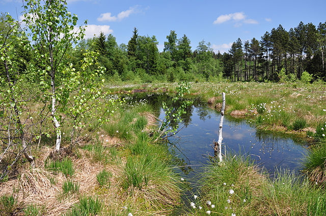
Deutsch: NSG-Breitenmoos bei Buchberg/Kempten.Freiflächen im Hochmoor mit Torfstichtümpeln und Birkenanflug, ideales Libellenhabitat. |
Date | |
Source | Own work |
Author | NorbertWLang |
Openstreetmap entry InfoField | Link to Openstreetmap |
Object location | 47° 40′ 14.06″ N, 10° 13′ 03.28″ E | View this and other nearby images on: OpenStreetMap | 47.670572; 10.217579 |
---|
Licensing
[edit]- You are free:
- to share – to copy, distribute and transmit the work
- to remix – to adapt the work
- Under the following conditions:
- attribution – You must give appropriate credit, provide a link to the license, and indicate if changes were made. You may do so in any reasonable manner, but not in any way that suggests the licensor endorses you or your use.
- share alike – If you remix, transform, or build upon the material, you must distribute your contributions under the same or compatible license as the original.
This image was uploaded as part of Wiki Loves Earth 2015.
aragonés | العربية | asturianu | azərbaycanca | беларуская (тарашкевіца) | български | বাংলা | brezhoneg | català | čeština | Cymraeg | Deutsch | Ελληνικά | English | español | eesti | euskara | فارسی | français | galego | עברית | hrvatski | հայերեն | Bahasa Indonesia | italiano | 日本語 | ქართული | 한국어 | latviešu | македонски | മലയാളം | मराठी | Bahasa Melayu | norsk bokmål | नेपाली | Nederlands | norsk | polski | português | português do Brasil | русский | sicilianu | shqip | slovenščina | српски / srpski | svenska | ไทย | Türkçe | українська | اردو | 中文 | 中文(台灣) | +/− |
This image has been assessed using the Quality image guidelines and is considered a Quality image.
العربية ∙ جازايرية ∙ беларуская ∙ беларуская (тарашкевіца) ∙ български ∙ বাংলা ∙ català ∙ čeština ∙ Cymraeg ∙ Deutsch ∙ Schweizer Hochdeutsch ∙ Zazaki ∙ Ελληνικά ∙ English ∙ Esperanto ∙ español ∙ eesti ∙ euskara ∙ فارسی ∙ suomi ∙ français ∙ galego ∙ עברית ∙ हिन्दी ∙ hrvatski ∙ magyar ∙ հայերեն ∙ Bahasa Indonesia ∙ italiano ∙ 日本語 ∙ Jawa ∙ ქართული ∙ 한국어 ∙ kurdî ∙ Lëtzebuergesch ∙ lietuvių ∙ македонски ∙ മലയാളം ∙ मराठी ∙ Bahasa Melayu ∙ Nederlands ∙ Norfuk / Pitkern ∙ polski ∙ português ∙ português do Brasil ∙ rumantsch ∙ română ∙ русский ∙ sicilianu ∙ slovenčina ∙ slovenščina ∙ shqip ∙ српски / srpski ∙ svenska ∙ தமிழ் ∙ తెలుగు ∙ ไทย ∙ Tagalog ∙ toki pona ∙ Türkçe ∙ українська ∙ vèneto ∙ Tiếng Việt ∙ 中文 ∙ 中文(简体) ∙ 中文(繁體) ∙ +/− |
File history
Click on a date/time to view the file as it appeared at that time.
Date/Time | Thumbnail | Dimensions | User | Comment | |
---|---|---|---|---|---|
current | 17:26, 27 May 2015 | 4,288 × 2,848 (13.98 MB) | NorbertWLang (talk | contribs) | User created page with UploadWizard |
You cannot overwrite this file.
File usage on Commons
The following 7 pages use this file:
- User:Holger1959/WLE15/DE/BY/2015 May 27
- User:Holger1959/WLE15/DE/schön
- User talk:NorbertWLang
- Commons:Files used on OpenStreetMap/131
- Commons:Quality images/Subject/Places/Natural structures/archive 2015
- Commons:Quality images candidates/Archives August 23 2015
- Category:FFH-Gebiet Moore im Wirlinger Wald
File usage on other wikis
The following other wikis use this file:
- Usage on de.wikipedia.org
- Usage on ro.wikipedia.org
- Usage on sv.wikipedia.org
- Usage on www.wikidata.org
Metadata
This file contains additional information such as Exif metadata which may have been added by the digital camera, scanner, or software program used to create or digitize it. If the file has been modified from its original state, some details such as the timestamp may not fully reflect those of the original file. The timestamp is only as accurate as the clock in the camera, and it may be completely wrong.
Camera manufacturer | NIKON CORPORATION |
---|---|
Camera model | NIKON D5000 |
Exposure time | 1/160 sec (0.00625) |
F-number | f/14 |
ISO speed rating | 200 |
Date and time of data generation | 12:42, 13 May 2011 |
Lens focal length | 18 mm |
Width | 4,288 px |
Height | 2,848 px |
Compression scheme | Uncompressed |
Pixel composition | RGB |
Orientation | Normal |
Horizontal resolution | 300 dpi |
Vertical resolution | 300 dpi |
Data arrangement | chunky format |
Software used | Ver.1.00 |
File change date and time | 17:16, 26 May 2015 |
Y and C positioning | Centered |
Exposure Program | Shutter priority |
Exif version | 2.21 |
Date and time of digitizing | 12:42, 13 May 2011 |
Meaning of each component |
|
Image compression mode | 2 |
APEX exposure bias | 0 |
Maximum land aperture | 3.6 APEX (f/3.48) |
Metering mode | Pattern |
Light source | Unknown |
Flash | Flash did not fire |
DateTime subseconds | 50 |
DateTimeOriginal subseconds | 50 |
DateTimeDigitized subseconds | 50 |
Supported Flashpix version | 1 |
Color space | sRGB |
Sensing method | One-chip color area sensor |
File source | Digital still camera |
Scene type | A directly photographed image |
Custom image processing | Normal process |
Exposure mode | Auto exposure |
White balance | Auto white balance |
Digital zoom ratio | 1 |
Focal length in 35 mm film | 27 mm |
Scene capture type | Standard |
Scene control | None |
Contrast | Normal |
Saturation | Normal |
Sharpness | Normal |
Subject distance range | Unknown |
GPS tag version | 0.0.2.2 |
- On OSM
- Files with coordinates missing SDC location of creation
- CC-BY-SA-3.0
- Self-published work
- Images from Wiki Loves Earth 2015
- Images from Wiki Loves Earth 2015 in Germany
- Images from Wiki Loves Earth missing SDC depicts
- Images from Wiki Loves Earth missing SDC location of creation
- Quality images
- Quality images missing SDC depicts
- Images from Wiki Loves Earth 2015, DE-BY
- Uploaded via Campaign:wle-de-by
- Quality images from Wiki Loves Earth 2015 in Germany