File:North America - corrected from the observations communicated to the Royal Society at London and the Royal Academy at Paris - by Iohn Senex, F.R.S., 1710; Iohn Senex sculpt. NYPL1030124.tiff
Jump to navigation
Jump to search

Size of this JPG preview of this TIF file: 414 × 599 pixels. Other resolutions: 166 × 240 pixels | 332 × 480 pixels | 531 × 768 pixels | 708 × 1,024 pixels | 1,416 × 2,048 pixels | 4,040 × 5,843 pixels.
Original file (4,040 × 5,843 pixels, file size: 67.54 MB, MIME type: image/tiff)
Captions
Captions
Add a one-line explanation of what this file represents
Summary[edit]
| Description | North America : corrected from the observations communicated to the Royal Society at London and the Royal Academy at Paris / by Iohn Senex, F.R.S., 1710 ; Iohn Senex sculpt.; Lawrence H. Slaughter Collection of English maps, charts, globes, books and atlases / Atlases / [Modern geography: or all known countries in the world. Laid down from the latest observations and discoveries, communicated to the Royal Society of London and Academy of Sciences at Paris. To which is added the geography of the ancient world, showing in ... | |||||||||||||||||||||||
| Notes | Covers continent of North America, as then known, with Gulf of Mexico and Caribbean. ''Note 2.'') Shows boundaries, rivers, and principal settlements, with notes. ''Note 3.'') Dedicated to Anthony Hammond. ''Note 4.'') Includes decorative title cartouche depicting classical figures, with coat of arms. ''Note 5.'') NYPL copy in Map Div. 97-6042 is folded to 69 x 52 cm. ''Note 6.'') NYPL copy in Map Div. 97-6042 is Lawrence H. Slaughter Collection 739. ''Note 7.'') Lawrence H. Slaughter Collection ; 739. | |||||||||||||||||||||||
| Catalogue call number | Map Div. 97-6042 ([Map 4])[In LHS 318] | |||||||||||||||||||||||
| Item physical description | 1 map : hand col. ; 94 x 66 cm. | |||||||||||||||||||||||
| Date | between 1708 and 1725 | |||||||||||||||||||||||
| Source |
http://digitalgallery.nypl.org/nypldigital/dgkeysearchdetail.cfm?imageID=1030124
|
|||||||||||||||||||||||
| Author | John, d. 1740 -- Engraver Senex | |||||||||||||||||||||||
| Permission (Reusing this file) |
From The Lionel Pincus and Princess Firyal Map Division. http://maps.nypl.org
|
|||||||||||||||||||||||
| Source description | 34 maps (33 col.) on 34 leaves (some folded). ; 69 cm. | |||||||||||||||||||||||
| Location | Stephen A. Schwarzman Building / The Lionel Pincus and Princess Firyal Map Division | |||||||||||||||||||||||
| Digital item published | 2-26-2005; updated 1-9-2012 | |||||||||||||||||||||||
| Digital ID | 1030124 | |||||||||||||||||||||||

The making of this file was supported by Wikimedia UK.
To see other files made with the support of Wikimedia UK, please see the category Supported by Wikimedia UK.
|
File history
Click on a date/time to view the file as it appeared at that time.
| Date/Time | Thumbnail | Dimensions | User | Comment | |
|---|---|---|---|---|---|
| current | 15:52, 2 May 2014 | 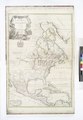 | 4,040 × 5,843 (67.54 MB) | Fæ (talk | contribs) | GWToolset:: Creating mediafile for Fæ. Tranche 3 11591-16518 @ 2 May, 06:47 BST |
You cannot overwrite this file.
File usage on Commons
There are no pages that use this file.