File:North and east shores of Lake Erie, from Buffalo to 79.20.jpg
Jump to navigation
Jump to search

Size of this preview: 800 × 338 pixels. Other resolutions: 320 × 135 pixels | 640 × 271 pixels | 1,766 × 747 pixels.
Original file (1,766 × 747 pixels, file size: 1.15 MB, MIME type: image/jpeg)
Captions
Captions
Add a one-line explanation of what this file represents
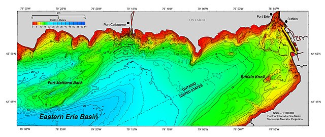
| Description | North and east shores of Lake Erie, from Buffalo to 79.20. | |||
| Source | https://www.ngdc.noaa.gov/mgg/greatlakes/lakeerie_cdrom/html/e_images.htm | |||
| Author | NOAA | |||
| Permission (Reusing this file) |
|
File history
Click on a date/time to view the file as it appeared at that time.
| Date/Time | Thumbnail | Dimensions | User | Comment | |
|---|---|---|---|---|---|
| current | 00:25, 25 June 2017 | | 1,766 × 747 (1.15 MB) | Geo Swan (talk | contribs) | {{Information |Description=North and east shores of Lake Erie, from Buffalo to 79.20. |Source=https://www.ngdc.noaa.gov/mgg/greatlakes/lakeerie_cdrom/html/e_images.htm |Date= |Author=NOAA |Permission={{PD-USGov-NOAA}} |other_versions= }} [[Category:La... |
You cannot overwrite this file.
File usage on Commons
There are no pages that use this file.