File:Northwest Pacific cyclone 2017-10-24 2350Z.png
Jump to navigation
Jump to search

Size of this preview: 800 × 600 pixels. Other resolutions: 320 × 240 pixels | 640 × 480 pixels | 1,024 × 768 pixels | 1,280 × 960 pixels | 2,560 × 1,920 pixels | 3,600 × 2,700 pixels.
Original file (3,600 × 2,700 pixels, file size: 13.16 MB, MIME type: image/png)
Captions
Captions
Add a one-line explanation of what this file represents
Summary[edit]
| Description |
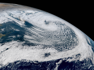
English: The Himawari-8 satellite captured a powerful typhoon-force extratropical cyclone east of the Kamchatka Peninsula late on October 24 (locally before noon on October 25), 2017. In terms of minimal pressure, it was the strongest extratropical cyclone of the Northern Hemisphere in 2017, which central pressure reached 934 hPa earlier. The energy from the remnants of Typhoon Lan triggered explosive cyglogenesis. |
| Date | |
| Source | RAMMB/CIRA SLIDER |
| Author | AHI image captured by the Japan Meteorological Agency’s Himawari-8 satellite |
| Camera location | | View this and other nearby images on: OpenStreetMap |
|---|
Licensing[edit]
This image is in the public domain because it contains materials that originally came from the U.S. National Oceanic and Atmospheric Administration, taken or made as part of an employee's official duties.
|
File history
Click on a date/time to view the file as it appeared at that time.
| Date/Time | Thumbnail | Dimensions | User | Comment | |
|---|---|---|---|---|---|
| current | 09:30, 23 January 2018 | | 3,600 × 2,700 (13.16 MB) | Meow (talk | contribs) | Slightly adjusted the hue. |
| 06:56, 25 October 2017 |  | 3,600 × 2,700 (13.03 MB) | Meow (talk | contribs) | User created page with UploadWizard |
You cannot overwrite this file.
File usage on Commons
There are no pages that use this file.
File usage on other wikis
The following other wikis use this file:
- Usage on ar.wikipedia.org
- Usage on el.wikipedia.org
- Usage on en.wikipedia.org
- Usage on it.wikipedia.org