File:OpenSeaMap-Kunst.jpg
Jump to navigation
Jump to search

Size of this preview: 800 × 528 pixels. Other resolutions: 320 × 211 pixels | 640 × 422 pixels | 1,024 × 675 pixels | 1,375 × 907 pixels.
Original file (1,375 × 907 pixels, file size: 251 KB, MIME type: image/jpeg)
Captions
Captions
Add a one-line explanation of what this file represents
Summary[edit]
| Description |
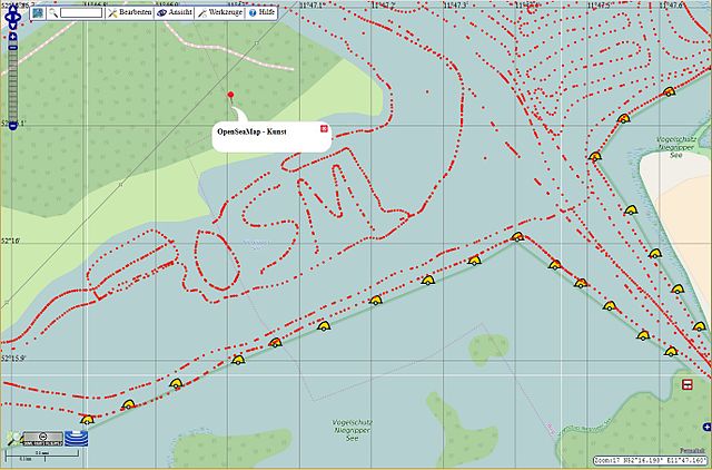
Deutsch: Künstlerisch gefahrener Track beim Erfassen von Wassertiefen.
Link zur Karte |
| Date | |
| Source | OpenSeaMap |
| Author | OpenSeaMap and team |
| Object location | | View this and other nearby images on: OpenStreetMap |
|---|
| Camera location | | View this and other nearby images on: OpenStreetMap |
|---|
Geokoordinate:
lat=52.27184 lon=11.78075
https://map.openseamap.org/?zoom=11&lat=52.28318&lon=11.68977&mlat=52.27184&mlon=11.78075&mtext=OSM-Kunst%20Wassertiefen%0An%C3%B6rdl.%20Magdeburg&layers=BFTFFFTFFTF0FFFFFFFFTT
Licensing[edit]
I, the copyright holder of this work, hereby publish it under the following licenses:

|
Permission is granted to copy, distribute and/or modify this document under the terms of the GNU Free Documentation License, Version 1.2 or any later version published by the Free Software Foundation; with no Invariant Sections, no Front-Cover Texts, and no Back-Cover Texts. A copy of the license is included in the section entitled GNU Free Documentation License. |
This file is licensed under the Creative Commons Attribution-Share Alike 3.0 Unported, 2.5 Generic, 2.0 Generic and 1.0 Generic license.
- You are free:
- to share – to copy, distribute and transmit the work
- to remix – to adapt the work
- Under the following conditions:
- attribution – You must give appropriate credit, provide a link to the license, and indicate if changes were made. You may do so in any reasonable manner, but not in any way that suggests the licensor endorses you or your use.
- share alike – If you remix, transform, or build upon the material, you must distribute your contributions under the same or compatible license as the original.
You may select the license of your choice.
File history
Click on a date/time to view the file as it appeared at that time.
| Date/Time | Thumbnail | Dimensions | User | Comment | |
|---|---|---|---|---|---|
| current | 13:25, 23 April 2016 | | 1,375 × 907 (251 KB) | Markus Bärlocher (talk | contribs) | {{Information |Description ={{de|1=Künstlerisch gefahrener Track beim Erfassen von Wassertiefen. [http://map.openseamap.org/?zoom=17&lat=52.26679&lon=11.78631&mlat=52.26861&mlon=11.78343&mtext=%3Cb%3EOpenSeaMap%20-%20Kunst%3C%2Fb%3E&layers=BTTFFFT... |
You cannot overwrite this file.
File usage on Commons
There are no pages that use this file.
File usage on other wikis
The following other wikis use this file:
- Usage on de.wikipedia.org