File:Pöchlarn - Donaubrücke.JPG
Jump to navigation
Jump to search

Size of this preview: 800 × 533 pixels. Other resolutions: 320 × 213 pixels | 640 × 427 pixels | 1,024 × 682 pixels | 1,280 × 853 pixels | 2,560 × 1,706 pixels | 4,251 × 2,833 pixels.
Original file (4,251 × 2,833 pixels, file size: 9.87 MB, MIME type: image/jpeg)
Captions
Captions
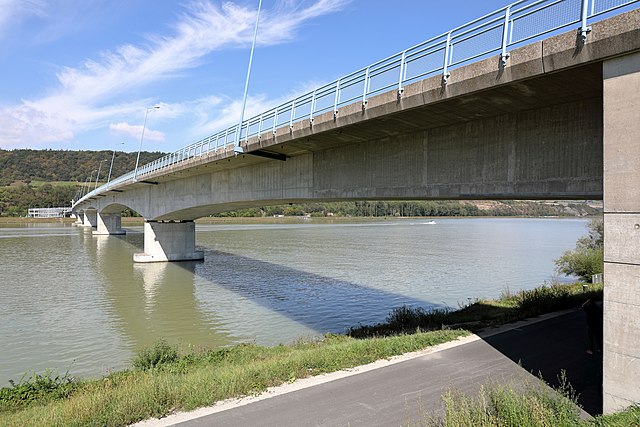
Danube bridge in Pöchlarn, Lower Austria
Summary[edit]
| Description |
Deutsch: Die Donaubrücke Pöchlarn vom rechten Flussufer aus gesehen. Sie verbindet die B3 (Donaustraße), linksseitig der Donau, und die B1 (Wiener Straße) bzw. A1 (Westautobahn), rechtsseitig der Donau. Die Spannbetonbrücke kostete 25,5 Millionen Euro (mit den Straßenanbindungen) und wurde nach dreieinhalb Jahren Bauzeit im Nov. 2002 für den Verkehr freigegeben. Die eigentliche Brücke, eine gevoutete Balkenbrücken in Hohlkasten-Bauweise, hat eine Länge von 460 m (Feldweiten: 72.50 m - 3 × 105.00 m - 72.50 m), die Vorlandbrücke im Norden eine von rd. 100m und die Straßenrampe im Süden eine von rd. 800 m. |
| Date | |
| Source | Own work |
| Author | C.Stadler/Bwag |
| Permission (Reusing this file) |
Deutsch: Hallo, du darfst mein Foto kostenlos nutzen, aber nenne mich bitte als Fotograf, beispielsweise „Foto: C.Stadler/Bwag“ oder © C.Stadler/Bwag; CC-BY-SA-4.0. Auf mehr Angaben bestehe ich nicht - im Gegensatz zu manch anderen, die die Vorgaben der unten angeführten Lizenzierung auf Punkt und Beistrich einfordern. English: Feel free to use my photos, but please mention me as the author like © C.Stadler/Bwag or © C.Stadler/Bwag; CC-BY-SA-4.0 (that's good enough) and if you want send me a message: bwag@gmx.net. |
| Object location | | View this and other nearby images on: OpenStreetMap |
|---|
| Camera location | | View this and other nearby images on: OpenStreetMap |
|---|
Licensing[edit]
I, the copyright holder of this work, hereby publish it under the following license:
This file is licensed under the Creative Commons Attribution-Share Alike 4.0 International license.
- You are free:
- to share – to copy, distribute and transmit the work
- to remix – to adapt the work
- Under the following conditions:
- attribution – You must give appropriate credit, provide a link to the license, and indicate if changes were made. You may do so in any reasonable manner, but not in any way that suggests the licensor endorses you or your use.
- share alike – If you remix, transform, or build upon the material, you must distribute your contributions under the same or compatible license as the original.
File history
Click on a date/time to view the file as it appeared at that time.
| Date/Time | Thumbnail | Dimensions | User | Comment | |
|---|---|---|---|---|---|
| current | 19:35, 14 September 2018 | | 4,251 × 2,833 (9.87 MB) | Bwag (talk | contribs) | n |
| 17:17, 14 September 2018 |  | 4,133 × 2,755 (9.16 MB) | Bwag (talk | contribs) | {{Information |Description= {{de|1= Die de:Donaubrücke Pöchlarn vom rechten Flussufer aus gesehen.<br/>Sie verbindet die B3 (Donaustraße), linksseitig der Donau, und die B1 (Wiener Straße) bzw. A1 (Westautobahn), rechtsseitig der Donau. Die Brücke kostete 25,5 Millionen Euro und wurde nach dreieinhalb Jahren Bauzeit im Nov. 2002 für den Verkehr freigegeben. Die eigentliche Brücke hat eine Länge von 460 m, die Vorlandbrücke im Norden eine von rd. 100m und die Straßenrampe im Süden eine v... |
You cannot overwrite this file.
File usage on Commons
The following page uses this file:
File usage on other wikis
The following other wikis use this file:
- Usage on de.wikipedia.org
- Usage on en.wikipedia.org
- Usage on fr.wikipedia.org
- Usage on www.wikidata.org