File:Paddy fields consolidation work in Nabeshimahonson 2018-01-26 01.jpg
Jump to navigation
Jump to search

Size of this preview: 800 × 400 pixels. Other resolutions: 320 × 160 pixels | 640 × 320 pixels | 1,024 × 512 pixels | 1,280 × 640 pixels | 2,560 × 1,280 pixels | 5,456 × 2,728 pixels.
Original file (5,456 × 2,728 pixels, file size: 9.55 MB, MIME type: image/jpeg)
Captions
Captions
Add a one-line explanation of what this file represents
Summary[edit]
| Description |
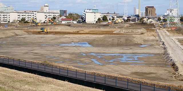
English: Land consolidation work of paddy fields in Nabeshima, Saga city, Saga prefecture. It is operated as "Farmland Infrastructure Consolidation Project" by prefecture with national government subsidy.
日本語: 水田における圃場整備工事の様子。佐賀市鍋島町鍋島にて。佐賀県の「鍋島本村地区 経営体育成基盤整備事業工事(ほ場整備工)」で、国庫補助がある。 |
| Date | |
| Source | Own work |
| Author | Peka |
| Camera location | | View this and other nearby images on: OpenStreetMap |
|---|
Licensing[edit]
I, the copyright holder of this work, hereby publish it under the following license:
This file is licensed under the Creative Commons Attribution-Share Alike 4.0 International license.
- You are free:
- to share – to copy, distribute and transmit the work
- to remix – to adapt the work
- Under the following conditions:
- attribution – You must give appropriate credit, provide a link to the license, and indicate if changes were made. You may do so in any reasonable manner, but not in any way that suggests the licensor endorses you or your use.
- share alike – If you remix, transform, or build upon the material, you must distribute your contributions under the same or compatible license as the original.
File history
Click on a date/time to view the file as it appeared at that time.
| Date/Time | Thumbnail | Dimensions | User | Comment | |
|---|---|---|---|---|---|
| current | 10:15, 7 February 2018 | | 5,456 × 2,728 (9.55 MB) | Peka (talk | contribs) | User created page with UploadWizard |
You cannot overwrite this file.
File usage on Commons
There are no pages that use this file.