File:Perejil.PNG
Jump to navigation
Jump to search

Size of this preview: 800 × 534 pixels. Other resolutions: 320 × 213 pixels | 640 × 427 pixels | 1,024 × 683 pixels | 1,162 × 775 pixels.
Original file (1,162 × 775 pixels, file size: 92 KB, MIME type: image/png)
Captions
Captions
Add a one-line explanation of what this file represents
Summary[edit]
| Description |
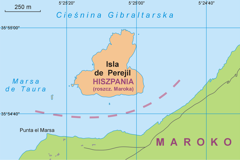
Polski: Mapa wyspy Perejil z zaznaczonym obszarem roszczeń Maroka
English: Map of Perejil Island with areas (in light orange) under Spanish administration claimed by Morocco |
| Date | |
| Source |
Polski: Praca własna na podstawie Estrecho de Gibraltar. Mapa Físico 1:100.000, Instituto Geográfico Nacional – SECEG 1989 [bmw] i obrazu satelitarnego Google Earth (dostęp 2010-07-15): tyretoria hiszpańskie wg Komisji Standaryzacji Nazw Geograficznych
English: Own work according to Estrecho de Gibraltar. Mapa Físico 1:100.000, Instituto Geográfico Nacional – SECEG 1989 and Google Earth sattelite images (as of 2010-07-15); Spanish territories according to the governmental Commission on Standardization of Geographical Names Outside the Republic of Poland |
| Author | Aotearoa |
| Other versions |
|


Licensing[edit]
I, the copyright holder of this work, hereby publish it under the following license:
This file is licensed under the Creative Commons Attribution 3.0 Unported license.
- You are free:
- to share – to copy, distribute and transmit the work
- to remix – to adapt the work
- Under the following conditions:
- attribution – You must give appropriate credit, provide a link to the license, and indicate if changes were made. You may do so in any reasonable manner, but not in any way that suggests the licensor endorses you or your use.
File history
Click on a date/time to view the file as it appeared at that time.
| Date/Time | Thumbnail | Dimensions | User | Comment | |
|---|---|---|---|---|---|
| current | 10:33, 12 November 2010 | | 1,162 × 775 (92 KB) | Mareklug (talk | contribs) | usunięto "l" w "del". Prawidłowa nazwa: Isla de Perejil |
| 13:57, 16 July 2010 |  | 1,162 × 775 (93 KB) | Aotearoa (talk | contribs) | drobne zmiany | |
| 20:48, 15 July 2010 |  | 1,162 × 775 (92 KB) | Aotearoa (talk | contribs) | {{Information |Description=Mapa wyspy Perejil |Source={{own}} |Date= |Author= Aotearoa |Permission= |other_versions= }} Category:Isla Perejil |
You cannot overwrite this file.
File usage on Commons
The following 2 pages use this file:
File usage on other wikis
The following other wikis use this file:
- Usage on pl.wikipedia.org