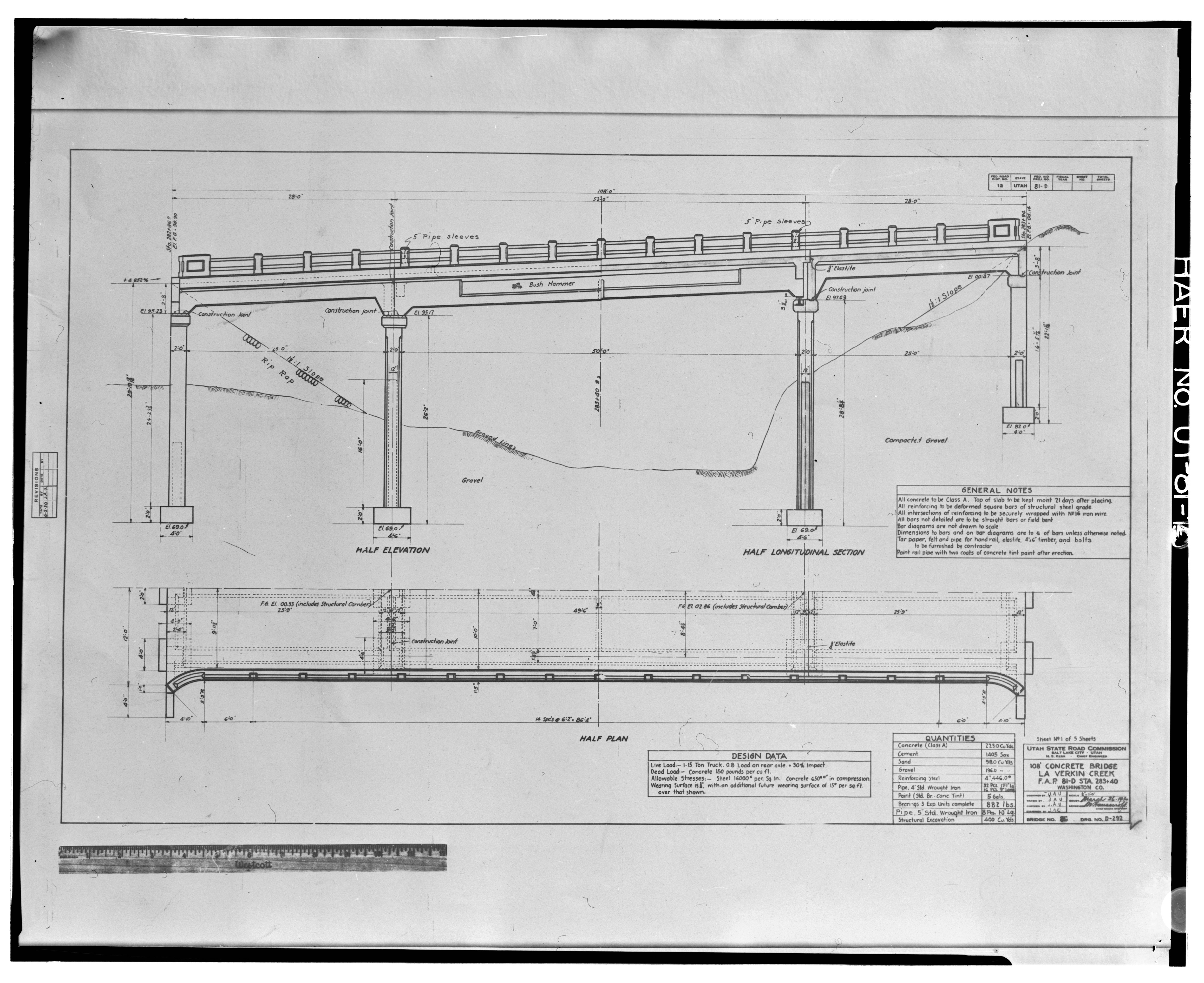
File:Photographic copy of original construction drawing, sheet no. 1 of 5, dated March 26, 1930, taken from a 11 x 17 print of a 2 x 2 negative in the possession of the Utah HAER UTAH,27-LAVE.V,1-10.tif
Jump to navigation
Jump to search

Size of this JPG preview of this TIF file: 735 × 600 pixels. Other resolutions: 294 × 240 pixels | 588 × 480 pixels | 941 × 768 pixels | 1,255 × 1,024 pixels | 2,510 × 2,048 pixels | 5,000 × 4,080 pixels.
Original file (5,000 × 4,080 pixels, file size: 19.46 MB, MIME type: image/tiff)
Captions
Captions
Add a one-line explanation of what this file represents
Summary[edit]
| Title |
Photographic copy of original construction drawing, sheet no. 1 of 5, dated March 26, 1930, taken from a 11 x 17 print of a 2 x 2 negative in the possession of the Utah Department of Transportation. HALF ELEVATION, HALF LONGITUDINAL SECTION AND HALF PLAN - La Verkin Creek Bridge, Spanning La Verkin Creek on State Route 17, 0.7 miles northwest of La Verkin , La Verkin, Washington County, UT |
|||
| Description |
Smith Balle Hyatt Architects, contractor; Hyatt, Kim A, photographer; Christensen, James R, historian |
|||
| Depicted place | Utah; Washington County; La Verkin | |||
| Date | Documentation compiled after 1968 | |||
| Dimensions | 4 x 5 in. | |||
| Current location |
Library of Congress Prints and Photographs Division Washington, D.C. 20540 USA http://hdl.loc.gov/loc.pnp/pp.print |
|||
| Accession number |
HAER UTAH,27-LAVE.V,1-10 |
|||
| Credit line |
|
|||
| Notes |
|
|||
| Source | https://www.loc.gov/pictures/item/ut0534.photos.375977p | |||
| Permission (Reusing this file) |
|

File history
Click on a date/time to view the file as it appeared at that time.
| Date/Time | Thumbnail | Dimensions | User | Comment | |
|---|---|---|---|---|---|
| current | 02:37, 4 August 2014 |  | 5,000 × 4,080 (19.46 MB) | Fæ (talk | contribs) | GWToolset: Creating mediafile for Fæ. HABS 2014-08-02 (3401:3600) |
You cannot overwrite this file.
File usage on Commons
The following page uses this file: