File:Photographic copy of photograph. (Source- U.S. Department of Interior. Office of Indian Affairs. Indian Irrigation Service. Annual Report, Fiscal Year 1925. Vol. I, Narrative HAER ARIZ,11-COOL,1D-13.tif
Jump to navigation
Jump to search

Size of this JPG preview of this TIF file: 747 × 600 pixels. Other resolutions: 299 × 240 pixels | 598 × 480 pixels | 957 × 768 pixels | 1,276 × 1,024 pixels | 2,552 × 2,048 pixels | 5,000 × 4,013 pixels.
Original file (5,000 × 4,013 pixels, file size: 19.14 MB, MIME type: image/tiff)
Captions
Captions
Add a one-line explanation of what this file represents
Summary[edit]
| Title |
Photographic copy of photograph. (Source- U.S. Department of Interior. Office of Indian Affairs. Indian Irrigation Service. Annual Report, Fiscal Year 1925. Vol. I, Narrative and Photographs, Irrigation District -4, California and Southern Arizona, RG 75, Entry 655, Box 28, National Archives, Washington, DC.) Photographer unknown. SACATON DAM AND BRIDGE, CONSTRUCTION OF MAIN APRON, 12-9-24 - San Carlos Irrigation Project, Sacaton Dam and Bridge, Gila River, T4S R6E S12-13, Coolidge, Pinal County, AZ |
|||
| Depicted place | Arizona; Pinal County; Coolidge | |||
| Dimensions | 4 x 5 in. | |||
| Current location |
Library of Congress Prints and Photographs Division Washington, D.C. 20540 USA http://hdl.loc.gov/loc.pnp/pp.print |
|||
| Accession number |
HAER ARIZ,11-COOL,1D-13 |
|||
| Credit line |
|
|||
| Source | https://www.loc.gov/pictures/item/az0391.photos.321674p | |||
| Permission (Reusing this file) |
|

| Camera location | | View this and other nearby images on: OpenStreetMap |
|---|
File history
Click on a date/time to view the file as it appeared at that time.
| Date/Time | Thumbnail | Dimensions | User | Comment | |
|---|---|---|---|---|---|
| current | 18:58, 1 July 2014 | 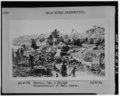 | 5,000 × 4,013 (19.14 MB) | Fæ (talk | contribs) | GWToolset: Creating mediafile for Fæ. HABS 1 July 2014 (201:300) |
You cannot overwrite this file.
File usage on Commons
The following page uses this file: