File:Pitt-Island map topo en.png
Jump to navigation
Jump to search
Size of this preview: 800 × 592 pixels. Other resolutions: 320 × 237 pixels | 640 × 474 pixels | 838 × 620 pixels.
Original file (838 × 620 pixels, file size: 70 KB, MIME type: image/png)
Captions
Captions
Add a one-line explanation of what this file represents
Summary[edit]
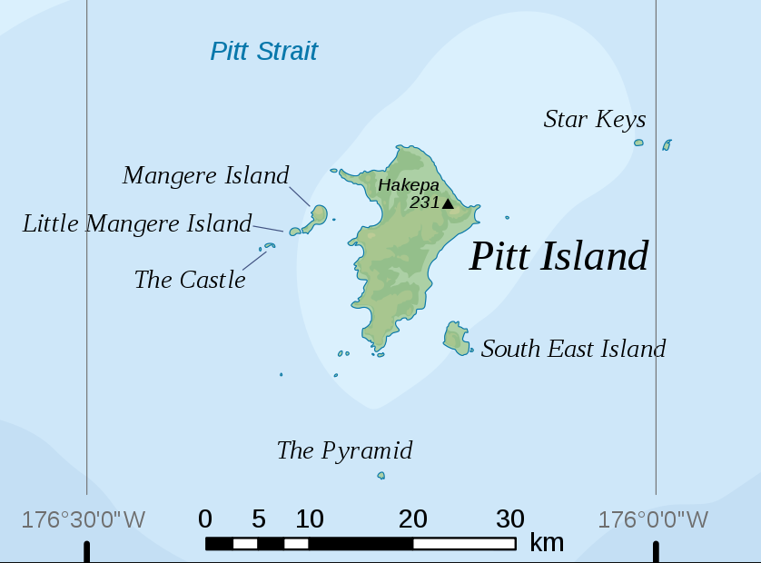
| Description |
Deutsch: Topographische Karte der Pitt-Insel, Chatham-Inseln, Neuseeland
English: Topographic map of Pitt Island, Chatham Islands, New Zealand |
| Date | |
| Source | Own work, based on original from User:Alexrk |
| Author | modified by Telim tor |
| Other versions |

Licensing[edit]
I, the copyright holder of this work, hereby publish it under the following license:
This file is licensed under the Creative Commons Attribution-Share Alike 2.5 Generic license.
- You are free:
- to share – to copy, distribute and transmit the work
- to remix – to adapt the work
- Under the following conditions:
- attribution – You must give appropriate credit, provide a link to the license, and indicate if changes were made. You may do so in any reasonable manner, but not in any way that suggests the licensor endorses you or your use.
- share alike – If you remix, transform, or build upon the material, you must distribute your contributions under the same or compatible license as the original.
File history
Click on a date/time to view the file as it appeared at that time.
| Date/Time | Thumbnail | Dimensions | User | Comment | |
|---|---|---|---|---|---|
| current | 07:00, 7 December 2009 | | 838 × 620 (70 KB) | Telim tor (talk | contribs) | == {{int:filedesc}} == {{Information |Description= {{de|Topographische Karte der Pitt-Insel, Chatham-Inseln, Neuseeland}} {{en|Topographic map of Pitt Island, Chatham Islands, New Zealand}} |Source={{own}}, based on original from [[User:Alexrk|Alexander K |
You cannot overwrite this file.
File usage on Commons
There are no pages that use this file.
File usage on other wikis
The following other wikis use this file:
- Usage on en.wikipedia.org
- Usage on pl.wikipedia.org
- Usage on www.wikidata.org