File:Plan routier de la ville de Paris et de ses faubourgs.tif
Jump to navigation
Jump to search

Size of this JPG preview of this TIF file: 800 × 564 pixels. Other resolutions: 320 × 226 pixels | 640 × 452 pixels | 1,024 × 723 pixels | 1,280 × 903 pixels | 2,560 × 1,806 pixels | 10,000 × 7,056 pixels.
Original file (10,000 × 7,056 pixels, file size: 201.9 MB, MIME type: image/tiff)
Captions
Captions
Add a one-line explanation of what this file represents
Summary[edit]
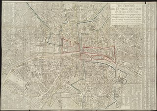
| Plan routier de la ville de Paris et de ses faubourgs, ou se trouvent indiqués tous les Changemens opérés jusqu'a ce jour avec les projets d'embellissemens, les nouv. les rues et P.ts pour servir de guide aux voyageurs ...
( |
|||||||||||||||||||||||||||
|---|---|---|---|---|---|---|---|---|---|---|---|---|---|---|---|---|---|---|---|---|---|---|---|---|---|---|---|
| Author |
Publisher: Esnault Jne. |
||||||||||||||||||||||||||
| Title |
Plan routier de la ville de Paris et de ses faubourgs, ou se trouvent indiqués tous les Changemens opérés jusqu'a ce jour avec les projets d'embellissemens, les nouv. les rues et P.ts pour servir de guide aux voyageurs ... |
||||||||||||||||||||||||||
| Description |
Map of Paris. |
||||||||||||||||||||||||||
| Date | 1819 | ||||||||||||||||||||||||||
| Dimensions | height: 54 cm (21.2 in); width: 78 cm (30.7 in) | ||||||||||||||||||||||||||
| Collection |
|
||||||||||||||||||||||||||
| Accession number |
G5834.P3 1819 .P53x |
||||||||||||||||||||||||||
| Source/Photographer | Norman B. Leventhal Map Center | ||||||||||||||||||||||||||

Licensing[edit]
|
This work is in the public domain in its country of origin and other countries and areas where the copyright term is the author's life plus 100 years or fewer. | |
| This file has been identified as being free of known restrictions under copyright law, including all related and neighboring rights. | |
File history
Click on a date/time to view the file as it appeared at that time.
| Date/Time | Thumbnail | Dimensions | User | Comment | |
|---|---|---|---|---|---|
| current | 03:15, 19 September 2017 |  | 10,000 × 7,056 (201.9 MB) | Paris 16 (talk | contribs) | User created page with UploadWizard |
You cannot overwrite this file.
File usage on Commons
The following page uses this file: