File:Plat book of Finney County, Kansas - containing maps of villages, cities and townships of the county, and of the state, United States and world - also portraits of representative citizens, old LOC 2010587335-5.jpg
Jump to navigation
Jump to search

Size of this preview: 800 × 465 pixels. Other resolutions: 320 × 186 pixels | 640 × 372 pixels | 1,024 × 595 pixels | 1,280 × 744 pixels | 2,560 × 1,488 pixels | 8,886 × 5,166 pixels.
Original file (8,886 × 5,166 pixels, file size: 6.71 MB, MIME type: image/jpeg)
Captions
Captions
Add a one-line explanation of what this file represents
Summary[edit]
| Description |
English: "Copyrighted 1910 by Western Pudlishing [sic] Co." Includes index, patrons reference directory with agricultural data, and portraits of early Finney County residents. Available also through the Library of Congress Web site as a raster image. LC copy imperfect: Front board separated from binding. Rear board wanting. Portrait pages badly foxed with some losses. Vendor: John Carbonell Acquisitions control no. 2009-082 |
||
| Title | Plat book of Finney County, Kansas : containing maps of villages, cities and townships of the county, and of the state, United States and world : also portraits of representative citizens, old settlers and leading men of the county, together with descriptive and agricultural data | ||
| Shelf ID | G1458.F4 W4 1911 | ||
| Parent | https://www.loc.gov/resource/g4203fm.gla00127/ | ||
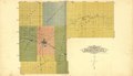
| Sheet title | Outline Map of Finney County, KS | ||
| Date | |||
| Source | https://www.loc.gov/item/2010587335/ | ||
| Author | Western Publishing Co. (Ashland, Kan.) | ||
| Permission (Reusing this file) |
|
||
| Other versions |
|
||
| Location | Finney County · United States · Kansas | ||
| Part of | American Memory · Catalog · County Landownership Maps · Geography And Map Division · Cultural Landscapes | ||
| Subject | Finney County · Directories · Portraits · Finney County (Kan.) · Kansas · United States · Maps · Real Property · Landowners · Biography |

Licensing[edit]
|
This is a faithful photographic reproduction of a two-dimensional, public domain work of art. The work of art itself is in the public domain for the following reason:
The official position taken by the Wikimedia Foundation is that "faithful reproductions of two-dimensional public domain works of art are public domain".
This photographic reproduction is therefore also considered to be in the public domain in the United States. In other jurisdictions, re-use of this content may be restricted; see Reuse of PD-Art photographs for details. | ||||
File history
Click on a date/time to view the file as it appeared at that time.
| Date/Time | Thumbnail | Dimensions | User | Comment | |
|---|---|---|---|---|---|
| current | 22:36, 11 June 2018 | | 8,886 × 5,166 (6.71 MB) | Fæ (talk | contribs) | LOC Maps multisheet https://www.loc.gov/item/2010587335/ sheet 5 of 53 #4092 |
You cannot overwrite this file.
File usage on Commons
The following page uses this file: