File:Plattegrond van Deshima.jpg
Jump to navigation
Jump to search

Size of this preview: 729 × 600 pixels. Other resolutions: 292 × 240 pixels | 584 × 480 pixels | 934 × 768 pixels | 1,245 × 1,024 pixels | 2,490 × 2,048 pixels | 3,213 × 2,643 pixels.
Original file (3,213 × 2,643 pixels, file size: 3.7 MB, MIME type: image/jpeg)
Captions
Captions
Add a one-line explanation of what this file represents
Summary
[edit]
| Description |
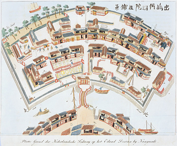
Nederlands: Plattegrond van de Nederlandse faktorij op het eiland Deshima bij Nagasaki English: Ground-plan of the Dutch trade-post on the island Dejima at Nagasaki |
| Date | between 1824 and 1825 |
| Source | Koninklijke Bibliotheek Bijzonderheden over Japan, behelzende een verslag van de huwelijks plechtigheden, begrafenissen en feesten der Japanezen, de gedenkschriften der laatste Japansche keizers, en andere merkwaardigheden nopens dat rijk |
| Creator |
Isaac Titsingh |
| Georeferencing | If inappropriate please set warp_status = skip to hide. |
| Other versions | Printed version in: I. Titsingh, Bijzonderheden over Japan, 's-The Hague, widow Allart, 1824-1825. Dl. 2. The Hague, Koninklijke Bibliotheek, Shelf number KW 114 L 22, plate after page 264 |
This digital media file - and/or the physical objects depicted on it - originates from the digital and/or physical collections of the Koninklijke Bibliotheek, national library of the Netherlands.
|
Licensing
[edit]
|
This is a faithful photographic reproduction of a two-dimensional, public domain work of art. The work of art itself is in the public domain for the following reason:
The official position taken by the Wikimedia Foundation is that "faithful reproductions of two-dimensional public domain works of art are public domain".
This photographic reproduction is therefore also considered to be in the public domain in the United States. In other jurisdictions, re-use of this content may be restricted; see Reuse of PD-Art photographs for details. | ||||
| Annotations | This image is annotated: View the annotations at Commons |
File history
Click on a date/time to view the file as it appeared at that time.
| Date/Time | Thumbnail | Dimensions | User | Comment | |
|---|---|---|---|---|---|
| current | 20:16, 1 September 2009 | | 3,213 × 2,643 (3.7 MB) | Jan Arkesteijn (talk | contribs) | {{Information |Description={{nl|1=Plattegrond van de Nederlandse faktorij op het eiland Desima bij Nangasaki}} |Source=[http://www.deverdiepingvannederland.nl/images/japan/index.html Koninklijke Bibliotheek] |Author=unknown |Date=17th century |Permission= |
You cannot overwrite this file.
File usage on Commons
The following 4 pages use this file:
File usage on other wikis
The following other wikis use this file:
- Usage on af.wikipedia.org
- Usage on ar.wikipedia.org
- Usage on azb.wikipedia.org
- Usage on ca.wikipedia.org
- Usage on cs.wikipedia.org
- Usage on da.wikipedia.org
- Usage on de.wikipedia.org
- Usage on en.wikipedia.org
- Usage on fi.wikipedia.org
- Usage on fr.wikipedia.org
- Usage on fy.wikipedia.org
- Usage on io.wikipedia.org
- Usage on ja.wikipedia.org
- Usage on ja.wikibooks.org
- Usage on ms.wikipedia.org
- Usage on nl.wikipedia.org
- Usage on no.wikipedia.org
- Usage on pt.wikipedia.org
- Usage on simple.wikipedia.org
- Usage on sl.wikipedia.org
- Usage on sq.wikipedia.org
- Usage on sv.wikipedia.org
- Usage on th.wikipedia.org
- Usage on vi.wikipedia.org
- Usage on www.wikidata.org
- Usage on zh.wikipedia.org