File:PonticKingdom.png
跳至導覽
跳至搜尋

預覽大小:718 × 600 像素。 其他解析度:287 × 240 像素 | 575 × 480 像素 | 919 × 768 像素 | 1,226 × 1,024 像素 | 1,551 × 1,296 像素。
原始檔案 (1,551 × 1,296 像素,檔案大小:265 KB,MIME 類型:image/png)
說明
說明
添加單行說明來描述出檔案所代表的內容
摘要
[編輯]

|
本圖片是以PNG、GIF或JPEG格式上傳。然而,其中包含的資料或訊息,應該重新建立成可縮放向量圖形(SVG)檔案,以更有效率或更準確的方式儲存。如有可能,請上傳本圖片的SVG格式版本。在上傳之後,請修改維基各姊妹計畫中所有使用舊版圖片的條目(列在圖像連結章節中),替換為新版圖片,並在舊圖片的描述頁中加入{{Vector version available|新圖片名稱.svg}}模板,同時移除本模板。
|
| 描述 |
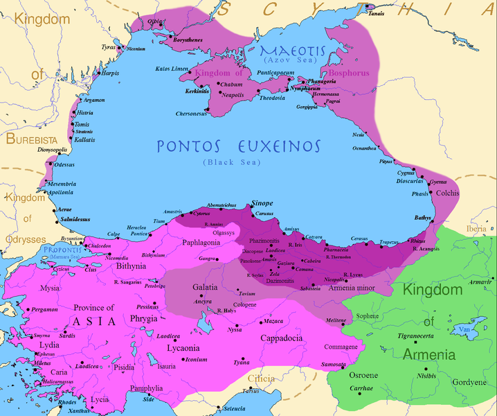
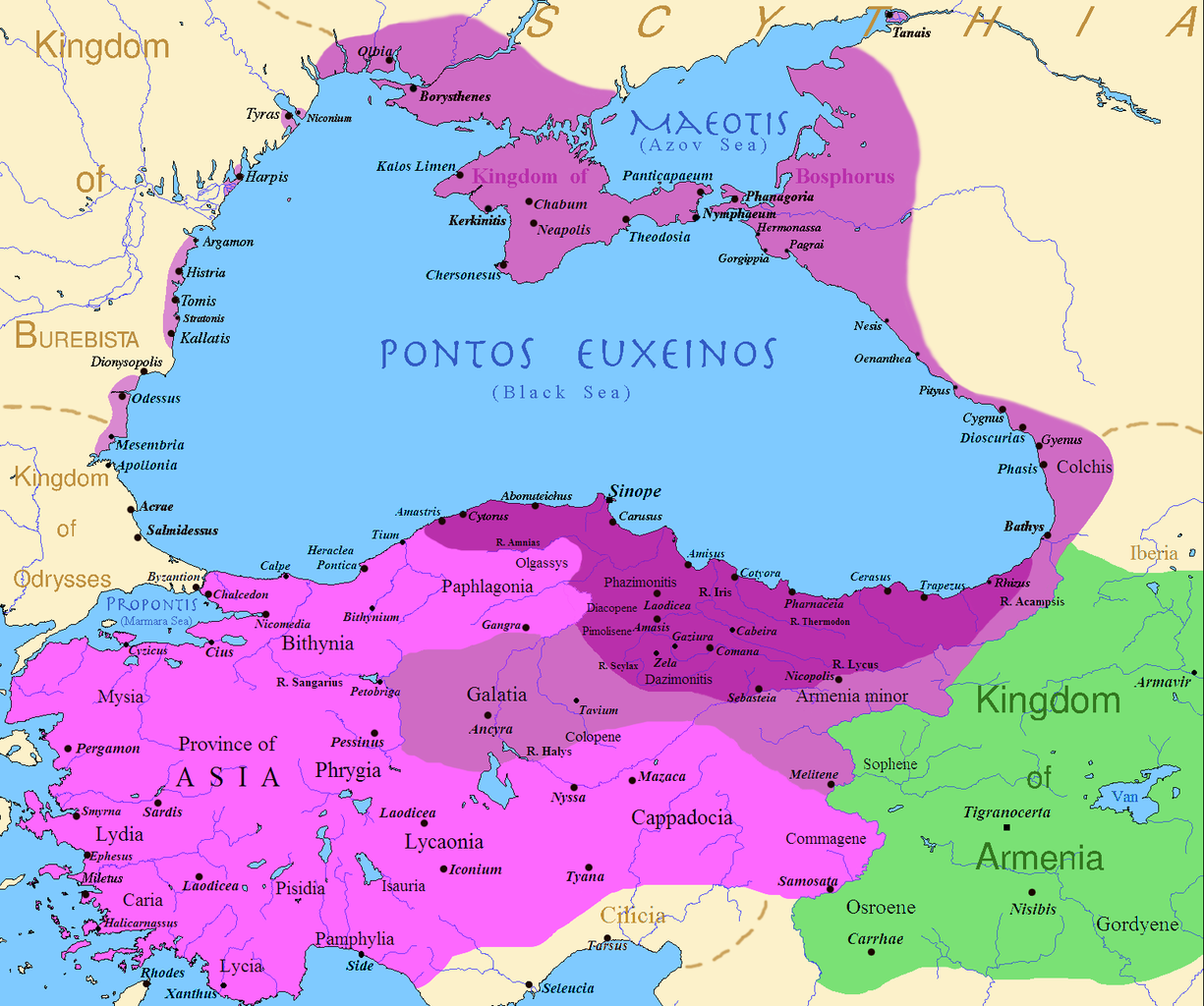
English: Map of the Kingdom of Pontus
Before the reign of Mithridates VI After his conquests His conquests in the first Mithridatic wars ; little adds (ancient shorelines & some greek colonies under Mithridate's rule) according with V. Yanko-Hombach, A.S. Gilbert, N. Panin, P. M. Dolukhanov: The Black Sea Flood Question: Changes in Coastline, Climate, and Human Settlement, Springer, Netherlands, 2007, and with Appianus, Plutarchus & Strabo. |
| 日期 | |
| 來源 | I (Javierfv1212 (talk)) created this work entirely by myself. Sources, Cambridge Ancient history volume 9, Penguin atlas of Greek history and the Foreign Policy of Mithridates VI Eupator. |
| 作者 | Javierfv1212 (talk) |
授權條款
[編輯]
| 此作品已由其作者,英文維基百科的Javierfv1212,釋出至公有領域。此授權條款在全世界均適用。 這可能在某些國家不合法,如果是的話: Javierfv1212授予任何人有權利使用此作品於任何用途,除受法律約束外,不受任何限制。 |
原始上傳日誌
[編輯]
Transferred from en.wikipedia to Commons by Falcorian using CommonsHelper.
The original description page was here. All following user names refer to en.wikipedia.
- 2009-07-19 23:42 Javierfv1212 1551×1296× (205182 bytes) {{Information |Description = Map of the Kingdom of Pontus, Before the reign of mithridates VI (darkest purple), after his conquests (purple), and his conquests in the first Mithridatic wars (pink). |Source = I (~~~) created this work entirel
檔案歷史
點選日期/時間以檢視該時間的檔案版本。
| 日期/時間 | 縮圖 | 尺寸 | 使用者 | 備註 | |
|---|---|---|---|---|---|
| 目前 | 2017年12月9日 (六) 02:00 | | 1,551 × 1,296(265 KB) | SteinsplitterBot(留言 | 貢獻) | Bot: Image rotated by 90° |
| 2017年12月9日 (六) 00:00 |  | 1,296 × 1,551(316 KB) | SteinsplitterBot(留言 | 貢獻) | Bot: Image rotated by 270° | |
| 2016年9月22日 (四) 17:54 |  | 1,551 × 1,296(265 KB) | Hohum(留言 | 貢獻) | Lighten water area | |
| 2016年8月9日 (二) 11:21 |  | 1,551 × 1,296(260 KB) | MAXHO(留言 | 貢獻) | Details : more cities & shoreline of this time | |
| 2015年10月1日 (四) 20:57 |  | 1,551 × 1,296(249 KB) | Spiridon Ion Cepleanu(留言 | 貢獻) | Cosmetic again | |
| 2015年9月30日 (三) 12:55 |  | 1,551 × 1,296(247 KB) | Spiridon Ion Cepleanu(留言 | 貢獻) | Cosmetic colours & background names | |
| 2014年4月7日 (一) 14:21 |  | 1,551 × 1,296(225 KB) | Spiridon Ion Cepleanu(留言 | 貢獻) | Little changes (ancient shoreline & some greek colonies under Pontic rule) according with V. Yanko-Hombach, A.S. Gilbert, N. Panin, P. M. Dolukhanov: ''The Black Sea Flood Question: Changes in Coastline, Climate, and Human Settlement'', Springer, Nethe... | |
| 2009年7月20日 (一) 04:14 |  | 1,551 × 1,296(200 KB) | File Upload Bot (Magnus Manske)(留言 | 貢獻) | {{BotMoveToCommons|en.wikipedia|year={{subst:CURRENTYEAR}}|month={{subst:CURRENTMONTHNAME}}|day={{subst:CURRENTDAY}}}} {{Information |Description={{en|Map of the Kingdom of Pontus, Before the reign of mithridates VI (darkest purple), after his conquests |
無法覆蓋此檔案。
檔案用途
全域檔案使用狀況
以下其他 wiki 使用了這個檔案:
- ar.wikipedia.org 的使用狀況
- ast.wikipedia.org 的使用狀況
- azb.wikipedia.org 的使用狀況
- az.wikipedia.org 的使用狀況
- bg.wikipedia.org 的使用狀況
- br.wikipedia.org 的使用狀況
- ca.wikipedia.org 的使用狀況
- cs.wikipedia.org 的使用狀況
- da.wikipedia.org 的使用狀況
- de.wikipedia.org 的使用狀況
- el.wikipedia.org 的使用狀況
- en.wikipedia.org 的使用狀況
- es.wikipedia.org 的使用狀況
- et.wikipedia.org 的使用狀況
- eu.wikipedia.org 的使用狀況
- fa.wikipedia.org 的使用狀況
- fr.wikipedia.org 的使用狀況
檢視此檔案的更多全域使用狀況。