File:Portishead rly map 1914.png
Jump to navigation
Jump to search

Size of this preview: 533 × 600 pixels. Other resolutions: 213 × 240 pixels | 426 × 480 pixels | 682 × 768 pixels | 1,098 × 1,236 pixels.
Original file (1,098 × 1,236 pixels, file size: 1.5 MB, MIME type: image/png)
Captions
Captions
Add a one-line explanation of what this file represents
Summary[edit]
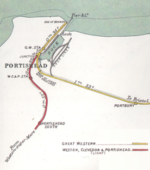
| Description | Map of the railways of Portishead, Somerset in 1914. |
| Date | |
| Source | File:Portishead Avonmouth RJD 157.jpg |
| Author | Original map by Railway Clearing House. Cropped, tilted and slightly edited by mattbuck. |
| Permission (Reusing this file) |
This file is licensed under the Creative Commons Attribution-Share Alike 3.0 Unported license.
|
| Other versions |
| Camera location | | View this and other nearby images on: OpenStreetMap |
|---|
File history
Click on a date/time to view the file as it appeared at that time.
| Date/Time | Thumbnail | Dimensions | User | Comment | |
|---|---|---|---|---|---|
| current | 13:42, 26 December 2008 | | 1,098 × 1,236 (1.5 MB) | Mattbuck (talk | contribs) | {{Information |Description=Map of the railways of {{w|Portishead, Somerset}} in 1914. |Source=File:Portishead Avonmouth RJD 157.jpg |Date=1914 |Author=Original map by {{w|Railway Clearing House}}. Cropped, tilted and slightly edited by [[User:Mattbuc |
You cannot overwrite this file.
File usage on Commons
There are no pages that use this file.
File usage on other wikis
The following other wikis use this file:
- Usage on azb.wikipedia.org
- Usage on en.wikipedia.org