File:Prefecture of Illyricum map-sr.png
Jump to navigation
Jump to search
Size of this preview: 607 × 600 pixels. Other resolutions: 243 × 240 pixels | 486 × 480 pixels | 778 × 768 pixels | 1,054 × 1,041 pixels.
Original file (1,054 × 1,041 pixels, file size: 92 KB, MIME type: image/png)
Captions
Captions
Add a one-line explanation of what this file represents
Summary[edit]
| Description |
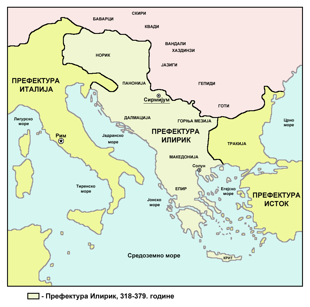
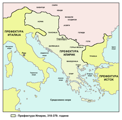
English: Historic map of Roman Praetorian Prefecture of Illyricum, 318-379 AD. Српски / srpski: Историјска карта римске преторијанске префектуре Илирик, 318-379. године. |
| Date | |
| Source | Own work |
| Author | PANONIAN |
| Other versions |
[]
|


Licensing[edit]
I, the copyright holder of this work, hereby publish it under the following license:
| This file is made available under the Creative Commons CC0 1.0 Universal Public Domain Dedication. | |
| The person who associated a work with this deed has dedicated the work to the public domain by waiving all of their rights to the work worldwide under copyright law, including all related and neighboring rights, to the extent allowed by law. You can copy, modify, distribute and perform the work, even for commercial purposes, all without asking permission.
|
References[edit]
- The Times History of Europe, Times Books, London, 2002.
- Dragan Brujić, Vodič kroz Svet antike, Beograd, 2005.
- Dragan Brujić, Vodič kroz Svet Vizantije, Beograd, 2004.
- Petar Milošević, Arheologija i istorija Sirmijuma, Novi Sad, 2001.
- http://sitemaker.umich.edu/mladjov/files/romanprefectures395s.jpg
- http://www.roman-empire.net/maps/empire/extent/constantine.html
- http://www.newadvent.org/cathen/07663a.htm
File history
Click on a date/time to view the file as it appeared at that time.
| Date/Time | Thumbnail | Dimensions | User | Comment | |
|---|---|---|---|---|---|
| current | 08:53, 17 July 2013 | | 1,054 × 1,041 (92 KB) | PANONIAN (talk | contribs) | {{Information |Description ={{en|1=Historic map of Roman Praetorian Prefecture of Illyricum, 318-379 AD.}} |Source ={{own}} |Author =PANONIAN |Date =2013 |Permission = |other_versions = }} |
You cannot overwrite this file.
File usage on Commons
The following 5 pages use this file:
File usage on other wikis
The following other wikis use this file:
- Usage on sr.wikipedia.org
Categories:
- Praetorian prefecture of Illyricum
- Maps of the history of the ancient Balkans
- Maps of Roman provinces
- Maps of 4th-century Europe
- Maps of the history of Vojvodina
- Maps of the history of Serbia in ancient times
- Maps of the history of Syrmia
- Maps of the history of Bosnia and Herzegovina in ancient times
- Maps of Illyricum
- Serbia in the 4th century
- Romania in the 4th century
- Maps of the history of Romania in ancient times
- Serbian-language maps