File:Prince William's Parish Church (Ruins), Sheldon vicinity (Beaufort County, South Carolina).jpg
Prince_William's_Parish_Church_(Ruins),_Sheldon_vicinity_(Beaufort_County,_South_Carolina).jpg (588 × 411 pixels, file size: 131 KB, MIME type: image/jpeg)
Captions
Captions
|
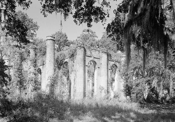
This is an image of a place or building that is listed on the National Register of Historic Places in the United States of America. Its reference number is 70000562. |
| Description |
English: Prince William's Parish Church (Ruins), Sheldon vicinity (Beaufort County, South Carolina) - (cropped)
|
|||||||||
| Date | ||||||||||
| Source | http://memory.loc.gov/cgi-bin/displayPhoto.pl?path=/pnp/habshaer/sc/sc0200/sc0277/photos&topImages=151946pr.jpg&topLinks=151946pv.jpg,151946pu.tif&title=HABS%20SC,7-SHELD,1-1&displayProfile=0 | |||||||||
| Author | Unknown author | |||||||||
| Permission (Reusing this file) |
|

,_Sheldon_vicinity_(Beaufort_County,_South_Carolina).jpg¶ms=032.618528_N_-080.780472_E_globe:Earth_class:object_region:US_type:landmark_scale:1500_&language=en)
File history
Click on a date/time to view the file as it appeared at that time.
| Date/Time | Thumbnail | Dimensions | User | Comment | |
|---|---|---|---|---|---|
| current | 19:27, 4 July 2008 | | 588 × 411 (131 KB) | KudzuVine (talk | contribs) | {{Information |Description={{en|1=Prince William's Parish Church (Ruins), Sheldon vicinity (Beaufort County, South Carolina) - (cropped) {{PD-USGov-Interior-HABS}}}} |Source=http://memory.loc.gov/cgi-bin/displayPhoto.pl?path=/pnp/habshaer/sc/sc0200/sc0277 |
You cannot overwrite this file.
File usage on Commons
There are no pages that use this file.
File usage on other wikis
The following other wikis use this file:
- Usage on azb.wikipedia.org
- Usage on en.wikipedia.org
- Usage on fa.wikipedia.org
- Usage on fr.wikipedia.org
- Usage on lld.wikipedia.org
- Usage on ro.wikipedia.org
- Usage on www.wikidata.org
,_Sheldon_vicinity_(Beaufort_County,_South_Carolina).jpg&oldid=705752473)