File:Punjab 1903.gif
跳转到导航
跳转到搜索
没有更高的分辨率。
Punjab_1903.gif (640 × 480像素,文件大小:338 KB,MIME类型:image/gif)
说明
说明
添加一行文字以描述该文件所表现的内容
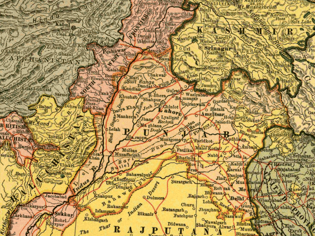
In this map, the British Raj Punjab province is colored pink, and the Indian princely states are colored yellow. As the map indicates, a number of princely states, mostly in the eastern Punjab, fell under the political authority of the British Governor of the Punjab. From map of India by Dodd, Mead and Company, 1903. Library of Congress Geography and Map Collection. Call Number G7650 1903 .D6 TIL
|
本作品在其来源国以及其他著作权期限是作者逝世后70年或以下的国家和地区属于公有领域。 | |
| 本文件已被确认为免除已知的著作权法限制(包括所有相关权利)。 | |
文件历史
点击某个日期/时间查看对应时刻的文件。
| 日期/时间 | 缩略图 | 大小 | 用户 | 备注 | |
|---|---|---|---|---|---|
| 当前 | 2005年5月6日 (五) 12:54 | | 640 × 480(338 KB) | Shauni(留言 | 贡献) | In this map, the British Raj Punjab province is colored pink, and the Indian princely states are colored yellow. As the map indicates, a number of princely states, mostly in the eastern Punjab, fell under the political authority of the British Gov |
您不可以覆盖此文件。
文件用途
以下页面使用本文件:
全域文件用途
以下其他wiki使用此文件:
- ar.wikipedia.org上的用途
- bg.wikipedia.org上的用途
- bn.wikipedia.org上的用途
- br.wikipedia.org上的用途
- ca.wikipedia.org上的用途
- en.wikipedia.org上的用途
- es.wikipedia.org上的用途
- fi.wikipedia.org上的用途
- hi.wikipedia.org上的用途
- it.wikipedia.org上的用途
- ko.wikipedia.org上的用途
- ml.wikipedia.org上的用途
- nn.wikipedia.org上的用途
- pnb.wikipedia.org上的用途
- ur.wikipedia.org上的用途
- www.wikidata.org上的用途
- zh.wikipedia.org上的用途