File:Région métropolitaine de Shawinigan-blank.svg
Jump to navigation
Jump to search

Size of this PNG preview of this SVG file: 429 × 600 pixels. Other resolutions: 171 × 240 pixels | 343 × 480 pixels | 549 × 768 pixels | 732 × 1,024 pixels | 1,464 × 2,048 pixels | 1,529 × 2,138 pixels.
Original file (SVG file, nominally 1,529 × 2,138 pixels, file size: 213 KB)
Captions
Captions
Add a one-line explanation of what this file represents
Summary[edit]
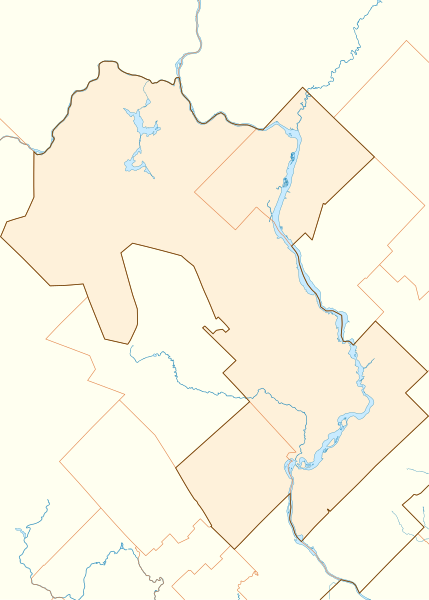
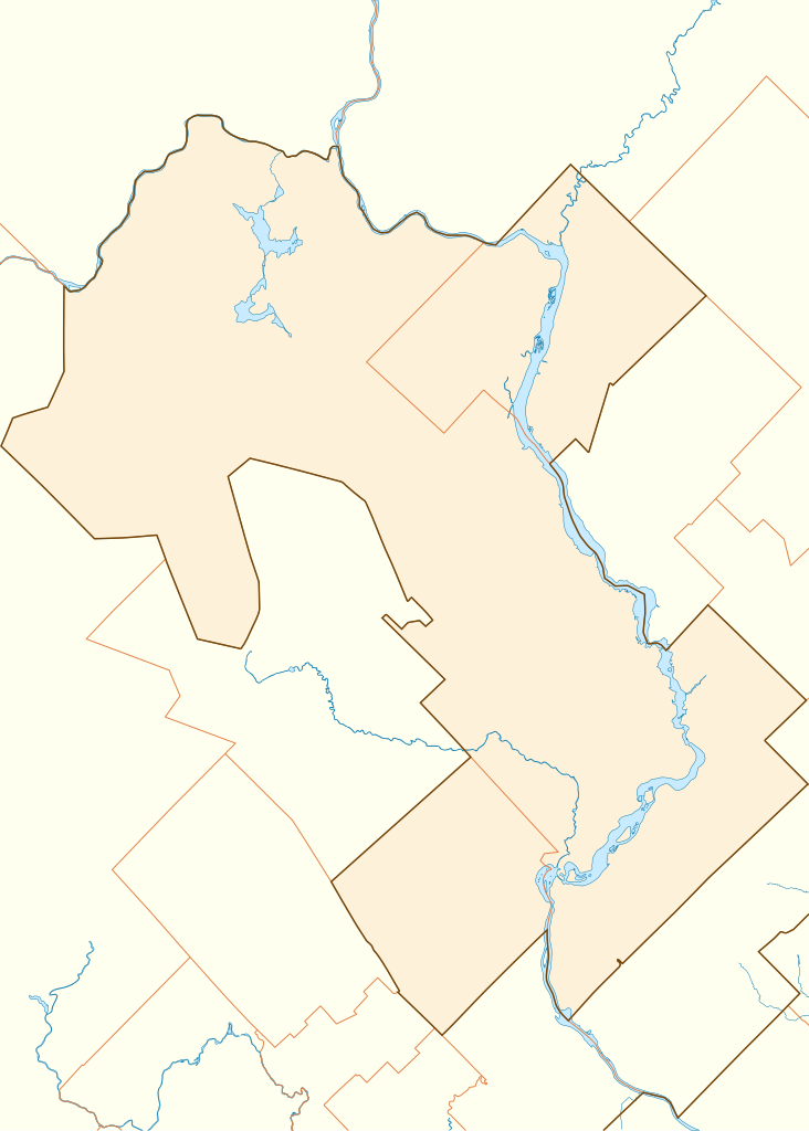
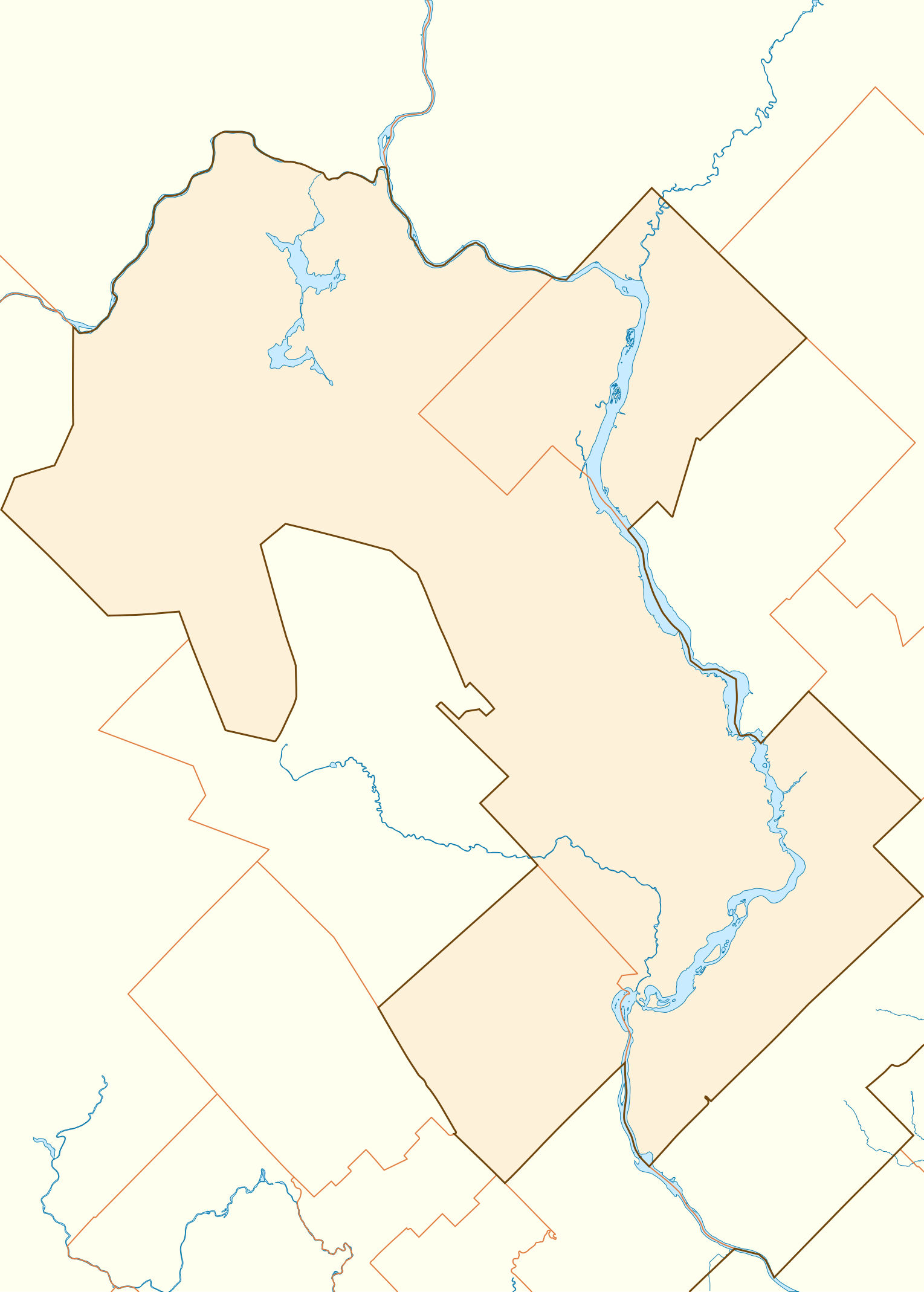
| Description |
Français : Carte vierge de la région métropolitaine de Shawinigan (Québec), affichant son contour, le découpage des municipalités qui la composent, et ses principaux cours d'eau.
Projection conique conforme de Lambert.
Le nord est parallèle aux côtés de la carte et dirigé vers le haut. Un calque caché contient le nom des municipalités qui composent la région. |
||
| Date | |||
| Source | Shawinigan - Aire de diffusion selon AR non subdivisées en SR (PDF). Statistique Canada, Division de la géographie (2011-12-08). Retrieved on 2013-08-31. | ||
| Author | Sémhur (talk) | ||
| Attribution (required by the license) | © Sémhur / Wikimedia Commons / | ||
| SVG | W3C-validity not checked.
|
||
| Graphic Lab |

| Camera location | | View this and other nearby images on: OpenStreetMap |
|---|
Licensing[edit]
I, the copyright holder of this work, hereby publish it under the following licenses:
| Copyleft: This work of art is free; you can redistribute it and/or modify it according to terms of the Free Art License. You will find a specimen of this license on the Copyleft Attitude site as well as on other sites. |
This file is licensed under the Creative Commons Attribution-Share Alike 4.0 International, 3.0 Unported, 2.5 Generic, 2.0 Generic and 1.0 Generic license.
- You are free:
- to share – to copy, distribute and transmit the work
- to remix – to adapt the work
- Under the following conditions:
- attribution – You must give appropriate credit, provide a link to the license, and indicate if changes were made. You may do so in any reasonable manner, but not in any way that suggests the licensor endorses you or your use.
- share alike – If you remix, transform, or build upon the material, you must distribute your contributions under the same or compatible license as the original.
You may select the license of your choice.
File history
Click on a date/time to view the file as it appeared at that time.
| Date/Time | Thumbnail | Dimensions | User | Comment | |
|---|---|---|---|---|---|
| current | 18:00, 31 August 2013 | | 1,529 × 2,138 (213 KB) | Sémhur (talk | contribs) | 2 - Noms des villes masqués |
| 17:55, 31 August 2013 |  | 1,529 × 2,138 (213 KB) | Sémhur (talk | contribs) | =={{int:filedesc}}== {{Information |description={{fr|1=Carte vierge de la région métropolitaine de Shawinigan (Québec), affichant son contour, le découpage des municipalités qui la composent, et ses principaux cours d'eau. Projection conique conf... |
You cannot overwrite this file.
File usage on Commons
There are no pages that use this file.
File usage on other wikis
The following other wikis use this file:
- Usage on fr.wikipedia.org
- Shawinigan
- Cégep de Shawinigan
- Église Saint-Pierre de Shawinigan
- Aréna Jacques-Plante
- Centrale de Grand-Mère
- Centrale du Rocher-de-Grand-Mère
- Cité de l'énergie
- Pont de Grand-Mère
- Église Notre-Dame-de-la-Présentation de Shawinigan
- Centre Gervais Auto
- Lac Wapizagonke
- Lac de la Tourbière
- Lac Gabet
- Modèle:Géolocalisation/Shawinigan
- Agglomération de recensement de Shawinigan
- Wikipédia:Atelier graphique/Cartes/Archives/septembre 2013
- Lac des Piles
- Île Melville (Québec)
- Lac du Caribou (Shawinigan)
- Lac Écarté (Shawinigan)
- Lac Anticagamac
- Parc de l'Île-Melville
- Lac des Cinq (Shawinigan)
- Lac Maréchal
- Caserne Champlain
- Chutes de Shawinigan
- Centrale de la N.A.C.
- Vallée du Parc
- Centrale de Shawinigan-1