File:Rhineland p myk.png
Jump to navigation
Jump to search
No higher resolution available.
Rhineland_p_myk.png (188 × 245 pixels, file size: 10 KB, MIME type: image/png)
Captions
Captions
Add a one-line explanation of what this file represents
Summary[edit]
| Description |
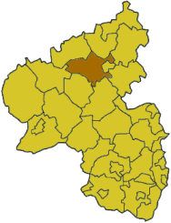
English: Map of Rhineland Palatinate highlighting the Mayen-Koblenz district
Based on the templates at en:Wikipedia:WikiProject German districts/Maptemplates |
| Date | 9 May 2003 (original upload date) |
| Source | Transferred from en.wikipedia to Commons by Sfan00_IMG using CommonsHelper. |
| Author | The original uploader was Ahoerstemeier at English Wikipedia. |
Licensing[edit]
| This file is licensed under the Creative Commons Attribution-Share Alike 3.0 Unported license. Subject to disclaimers. | ||
| ||
| This licensing tag was added to this file as part of the GFDL licensing update. |

|
Permission is granted to copy, distribute and/or modify this document under the terms of the GNU Free Documentation License, Version 1.2 or any later version published by the Free Software Foundation; with no Invariant Sections, no Front-Cover Texts, and no Back-Cover Texts. A copy of the license is included in the section entitled GNU Free Documentation License. Subject to disclaimers. |
Original upload log[edit]
The original description page was here. All following user names refer to en.wikipedia.
- 2003-05-09 22:02 Ahoerstemeier 188×245× (10215 bytes) Map of Rhineland Palatinate highlighting the Mayen-Koblenz district
File history
Click on a date/time to view the file as it appeared at that time.
| Date/Time | Thumbnail | Dimensions | User | Comment | |
|---|---|---|---|---|---|
| current | 14:50, 25 January 2009 | | 188 × 245 (10 KB) | File Upload Bot (Magnus Manske) (talk | contribs) | {{BotMoveToCommons|en.wikipedia}} {{Information |Description={{en|Map of Rhineland Palatinate highlighting the Mayen-Koblenz district Based on the templates at en:Wikipedia:WikiProject German districts/Maptemplates}} |Source=Transferred from [http: |
You cannot overwrite this file.
File usage on Commons
There are no pages that use this file.
File usage on other wikis
The following other wikis use this file:
- Usage on ms.wikipedia.org
- Usage on pnb.wikipedia.org
- Usage on vi.wikipedia.org